In Garfield County, an area of multiple land uses, geologic maps show the location and quality of the sand and gravel resources. Planners, citizens, and resource developers use this information to locate and evaluate potential deposits and make informed land-use choices.
Defining the Problem
As population and urban development have escalated along the Colorado River valley in Garfield County, Colorado, the demand for sand and gravel resources has increased dramatically. Sand and gravel are the basic materials used in most construction projects from roads and bridges to house foundations and office buildings. For example, construction of a small house requires an average of 250 tons of rock material. The relatively high cost to transport sand and gravel necessitates that these resources be obtained as close to where they will be used as possible.
The Geological Map
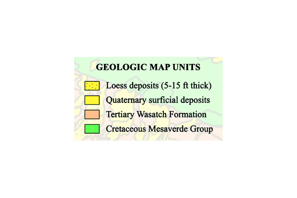
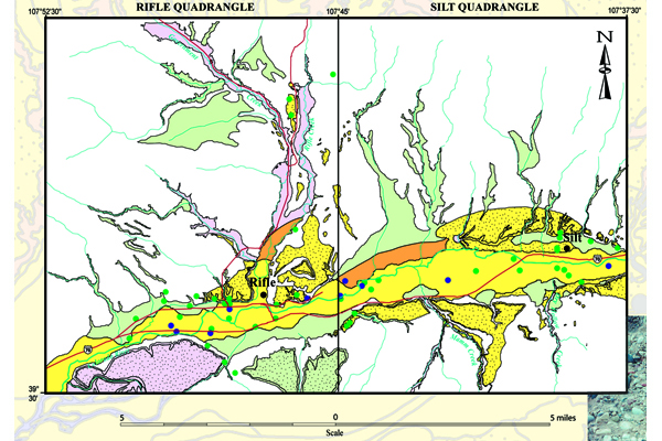
Geologic maps of the Colorado River valley (Fig. 1) show both bedrock and surface units. All of the geologic maps include descriptions of the unconsolidated sand and gravel units (yellow) as well as wind-blown deposits (loess) (yellow with black dots). Bedrock in the areas includes sedimentary rocks of the Tertiary Wasatch Formation (orange) and the Cretaceous Mesaverde Group (green).
Figure 1: Simplified geologic map of the Rifle and Silt quadrangles in Garfield County, Colorado. Yellow indicates unconsolidated sand and gravel deposits. Yellow with black dots indicates deposits of wind-blown silt (loess). Credit: USGS
Applying the Geologic Map
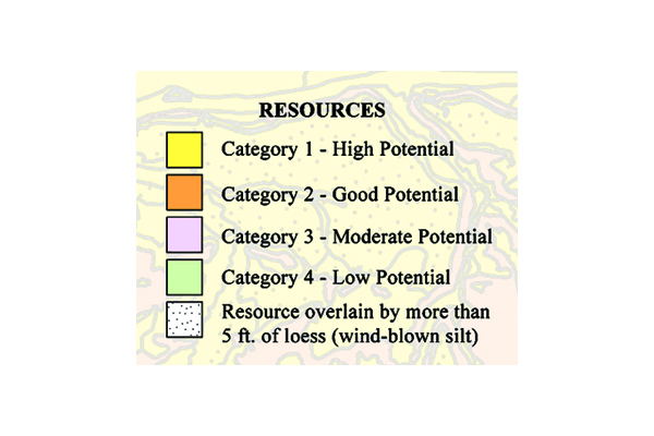
Geologic maps were the necessary starting point for delineating and characterizing sand and gravel resources in a study area. Field observations and map descriptions were used to group surface deposits according to their sand and gravel resource potential. Areas of high, good, moderate, and low sand and gravel resource potential were identified and outlined (Fig. 2). High potential sand and gravel areas, Category 1, include recent stream alluvium and terrace gravel characterized by moderately well-sorted, slightly bouldery, pebble- and cobble-gravel in a sandy or silty matrix. Good potential sand and gravel areas, Category 2, include glacial deposits, stream alluvium and terrace gravels in tributary drainages, and Colorado River terrace gravel. Moderate potential sand and gravel areas, Category 3, include pediment deposits, older mud-flow and debris-flow deposits, and some alluvial-fan deposits that contain volcanic pebbles and cobbles. Low potential sand and gravel areas, Category 4, include alluvium in some drainages tributary to the Colorado River, some alluvial-fan deposits, and modern debris-flow deposits.
Figure 2: High potential sand and gravel resources of the Rifle and Silt quadrangles in Garfield County, Colorado (yellow) include recent stream alluvium and terrace gravels. Credit: U.S. Geological Survey
Conclusion
In Garfield County, an area of multiple land uses, geologic maps show the location and quality of the sand and gravel resources. Planners, citizens, and resource developers use this information to locate and evaluate potential deposits and make informed land-use choices.
References
Shroba, R.R. and R.B. Scott, 2001. Geologic map of the Silt quadrangle, Garfield County, Colorado. U.S. Geological Survey Miscellaneous Field Studies Map MF-2331, scale 1:24,000.
Shroba, R.R. and R.B. Scott, 1997. Geologic map of the Rifle quadrangle, Garfield County, Colorado. U.S. Geological Survey Open-File Report OF 97-825, scale 1:24,000.
Widmann, B.L., 2002. Sand and gravel resources adjacent to the Colorado River Valley, Garfield County, Colorado. Colorado Geological Survey Open File Report OF 02-14, CD-ROM.
Additional Information
Case study authors: Beth L. Widmann and Jim Cappa (Colorado Geological Survey)
Case study from: Thomas, W.A. 2004. Meeting Challenges with Geologic Maps, p. 50-51. Published by the American Geosciences Institute Environmental Awareness Series. Click here to download the full handbook.


