From the U.S. Geological Survey FAQs:
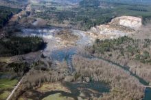
"Several kinds of maps are used to depict danger from landslides. These maps may be as simple as a map that uses the locations of old landslides to indicate potential instability, or as complex as a quantitative map incorporating probabilities based on variables such as rainfall, slope angle, soil type, and levels of earthquake shaking. The term “landslide hazard map” (see specific definition below) is sometimes loosely applied to any of these. The following types of maps are used to describe and depict landslide hazards:
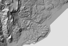
Landslide inventory maps show landslide locations and may show the dimensions and geographical extent of each landslide. Because one clue to the location of future landsliding is the distribution of past movement, maps that show the location and size of landslides are helpful in predicting the hazard for an area.
Examples of landslide inventory maps:
Inventory of Landslides Triggered by the 1994 Northridge, California, Earthquake
California Geological Survey Landslide Inventory Maps
Landslide susceptibility maps describe the relative likelihood of future landsliding based solely on the intrinsic properties of a locale or site. Some organizations use the term “landslide potential map” for maps of this kind. Prior failure (from a landslide inventory), rock or soil strength, and steepness of slope are three of the more important site factors that determine susceptibility.
Examples of landslide susceptibility maps:
Susceptibility to Deep-Seated Landslides in California
Landslide hazard maps indicate the possibility of landslides occurring throughout a given area. An ideal landslide hazard map shows not only the chances that a landslide may form at a particular place, but also the chance that it may travel downslope a given distance.
Examples of landslide hazard maps:
Shallow-Landslide Hazard Map of Seattle, Washington
Examples of potential landslide maps:
NASA Global Potential Landslide Areas
Landslide risk maps show landslide potential along with the expected losses to life and property, should a landslide occur. Risk maps combine the probability information from a landslide hazard map with an analysis of all possible consequences (property damage, casualties, and loss of service)."
Learn More
- Understanding Landslide Deposit Maps (Factsheet), Oregon Department of Geology and Mineral Industries
Explains landslide inventory maps, how to read them, why they are important, and how a landslide inventory map is created.
- Landslide Overview Map of the Conterminous United States (Map), U.S. Geological Survey
Overview map showing the landslide risks for the conterminous United States.
- Landslide Hazards Program (Website), U.S. Geological Survey
Website for the USGS Landslide Hazards Program, featuring hazard assessments, landslide reporting, selected state and local information, and educational resources.
- Identifying and Reducing Landslide Risk (Webinar) American Geosciences Institute
2019 webinar providing an overview of landslide risk assessment, mapping, and impacts in the United States, and featuring case studies of work done in and with communities to reduce landslide risk.


