Human and economic vulnerability in the Central United States
Earthquakes in the New Madrid Fault Zone
The New Madrid fault zone (NMFZ) is a long-established weakness in the Earth’s crust in the central and eastern US where earthquakes have occurred for hundreds of millions of years. In 1811-1812, three large earthquakes (up to magnitude 7.5) caused severe damage to the area.1 At the time, the region was sparsely populated; today it is a critical economic hub centered around Memphis, Tennessee, with a unique confluence of transportation and distribution centers. Small earthquakes still occur here regularly, and large earthquakes will occur here into the future, affecting all or part of at least 15 states in the central and eastern US.1
This region has a long history of large earthquakes. Earthquakes with a magnitude greater than 7 occur roughly every 500 years,2 with magnitude 5 to 6 earthquakes happening much more frequently. The largest earthquakes in the NMFZ often occur in series, with 3-5 large earthquakes within a few months, and thousands of smaller aftershocks that continue for months or years. This pattern of several large earthquakes was seen in the 1811-12 New Madrid earthquakes, as well as around 1450 CE, 900 CE, and 2300 BCE.2
Earthquake Hazards
Direct earthquake hazards include groundshaking, landslides, surface uplift and down-dropping, and soil liquefaction. The geology of the central US makes these effects more severe for two main reasons:
- The rocks do not absorb earthquake energy as well as those in the western US, so an earthquake of any given magnitude will affect a much larger area than a California earthquake of the same magnitude.3
- Earthquake groundshaking is more intense in places with layers of soft sediments, which amplify earthquake ground-shaking. The NMFZ lies beneath extremely thick sediments (up to 6000+ feet) deposited by the Mississippi River over millions of years. The region is therefore particularly vulnerable to intense groundshaking.3
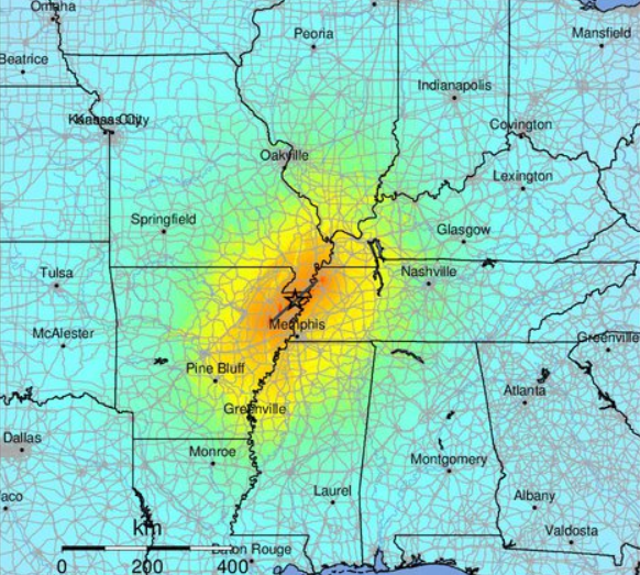
Expected shaking intensity of a magnitude 7.5 earthquake on the New Madrid central fault. Greens to yellows indicate moderate to strong shaking; oranges to reds indicate severe to extreme shaking and moderate to heavy damage. Credit: US Geological Survey
Human and Economic Risks
Earthquake hazards from the NMFZ pose a significant risk to much of the US. Regionally, a large earthquake will affect people, property, infrastructure, and market and supply sectors. However, the importance of the region as a transportation and distribution center means that a large earthquake would have serious ripple effects far beyond the area of shaking.
Buildings and Infrastructure
- Groundshaking affects structures such as buildings, bridges, levees, dams, and cell-phone and water towers. Most structures in the New Madrid region are not earthquake-resistant. Many places in the region have no building codes,4 and very few of the existing building codes require earthquake-resistant design.5
- Landslides, liquefaction, and surface uplift and downdropping affect regional and national infrastructure. This includes highways, pipelines, power grids, engineered drainage systems, river channels, domestic water and sewer systems, and rail lines.
Transportation and Distribution Networks
- The area around the NMFZ is a critical transportation confluence of air cargo, barges, railroads, and trucking.6 Almost half of the total US trucking capacity travels through this area. Commodity transport depends on open channels in the Mississippi, Missouri, and Ohio rivers. Rail lines converge across a small number of bridges over the Mississippi River; most of these predate earthquake-resistant engineering.7 Although some highway bridges have been designed or retrofitted to improve their earthquake resistance,8 rail bridges generally have not.
- Memphis is the closest large city to the NMFZ. Known as “America’s Distribution Center,” Memphis has the second-busiest cargo airport in the world.9 Many companies have concentrated their products in Memphis warehouses to take advantage of the favorable shipping and distribution networks. Much of the country’s inventory of surgical instruments, household goods, cotton, and automobile parts is located in Memphis. This puts a significant part of the national product supply chain at risk from a large earthquake in the NMFZ.
Industry and Agriculture
- Several major industries are concentrated in the NMFZ. Mississippi County, AR, is the second-largest primary steel-producing county in the US.10 Much of the country’s structural steel and tubular products (for pipelines, oil and gas production, and electrical conduits) are made in northeast Arkansas.11,12 These are also the kinds of products that will be needed to rebuild infrastructure damaged in a large earthquake, further increasing the region’s vulnerability.
- Agriculture in southeast Missouri, northeast Arkansas, and western Kentucky and Tennessee depends on engineered drainage systems. Much of the area was originally swamp. Because the land is flat and the soils are rich, rice, cotton, corn, and soybeans are intensively farmed. These large, flat croplands are vulnerable to the effects of uplift and down-dropping from large earthquakes, which will flood some areas that are now dry – destroying farmland – and will interrupt the flow of water in drainage ditches and natural channels.
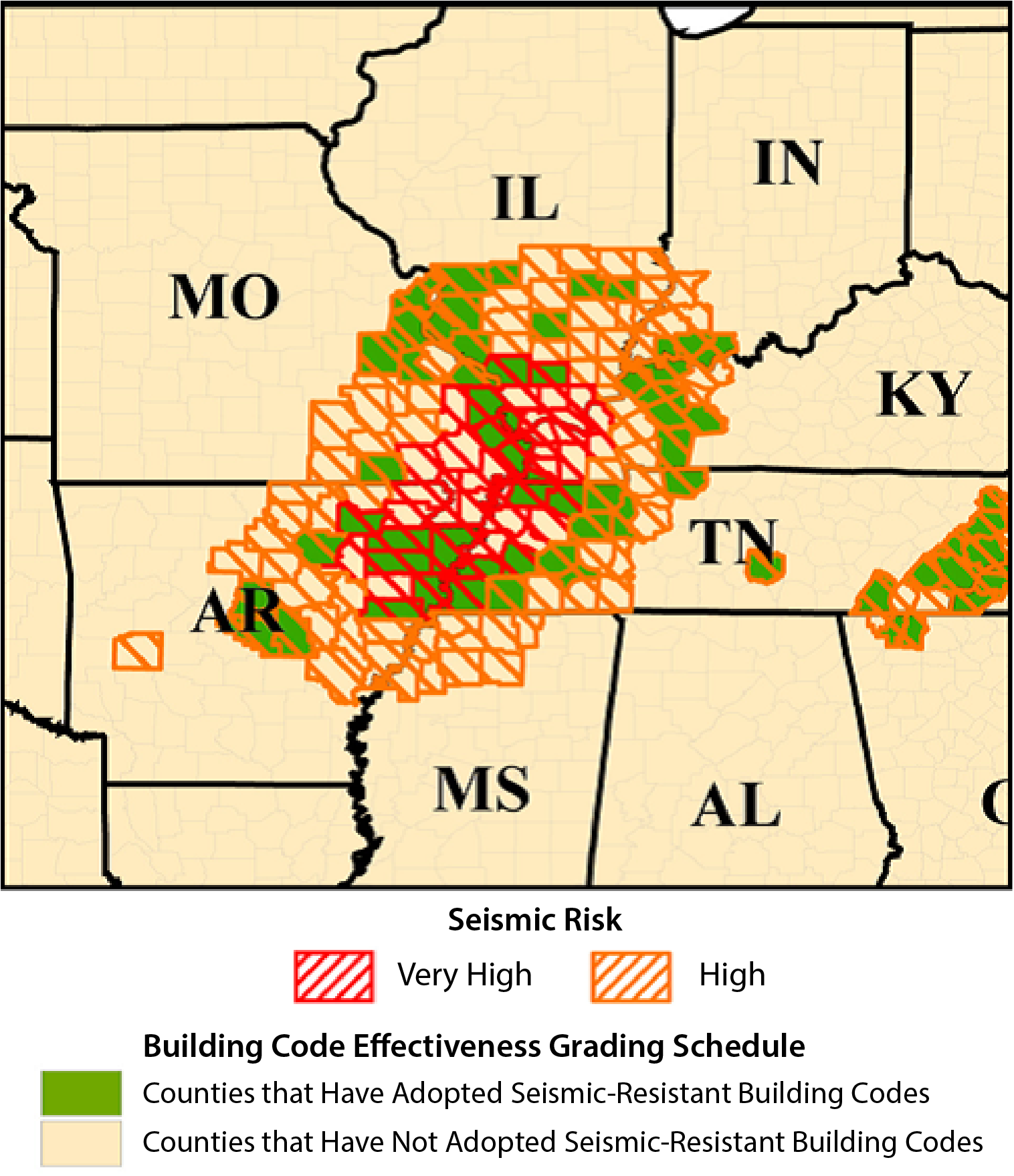
Many counties in the NMFZ have not adopted earthquake-resistant building codes. Image Credit: FEMA
Mitigation Strategies
Large, damaging earthquakes will occur along the NMFZ in the future. Many hazard mitigation strategies that have been successfully applied elsewhere can be applied here. These include the adoption of and compliance with building codes; considering earthquake hazards in site selection and land-use planning; and increased awareness of earthquake hazards and risks at all levels. For more information on specific strategies, see the More Resources section, below.
More Resources
New Madrid Seismic Zone, Central United States Earthquake Consortium
National Earthquake Hazards Reduction Program
The New Madrid Seismic Zone, U.S. Geological Survey
Facts about the New Madrid Seismic Zone, Missouri Geological Survey
Building Codes in the New Madrid Seismic Zone (NMSZ), U.S. Federal Emergency Management Agency
Earthquake Hazard Mitigation in the New Madrid Seismic Zone: Science and Public Policy, Kentucky Geological Survey
USGS Earthquake Scenario Map, U.S. Geological Survey
Missouri Earthquake Preparedness, Missouri State Emergency Management Agency
Earthquake Resources, University of Memphis Center for Earthquake Research and Information
Plane & Prepare: Earthquake, Arkansas Department of Emergency Management
Earthquake Engineering Research Institute
Missouri Seismic Safety Commission
References
1 1811-1812 New Madrid, Missouri Earthquakes, U.S. Geological Survey
2 Science of the New Madrid Seismic Zone, U.S. Geological Survey
3 Earthquake Hazard in the Heart of the Homeland, U.S. Geological Survey
4 County Building Codes for Missouri, State of Missouri Data Portal
5 Building Codes in the New Madrid Seismic Zone (NMSZ), U.S. Federal Emergency Management Agency
6 2013 Status of the Nation's Highways, Bridges, and Transit: Conditions & Performance, U.S. Department of Transportation
7 Earthquake Vulnerability of Transportation Systems in the Central United States, Central United States Earthquake Consortium
8 Keeping up Bridges in the New Madrid Seismic Zone, National Earthquake Hazards Reduction Program
9 Cargo Traffic 2016, Airports Council International
10 Steel (Factsheet), Arkansas Economic Development Commission
11 Nucor-Yamato Steel, Nucor-Yamato Steel
12 Handbook of Industry Studies and Economic Geography, Giarratani F, Hewings GJD, and McCann P, eds., Edward Elgar Publishing: Northampton, MA

This work is licensed under a Creative Commons Attribution-NonCommercial-NoDerivatives 4.0 International License.
You are free to share or distribute this material for non-commercial purposes as long as it retains this licensing information, and attribution is given to the American Geosciences Institute.

