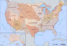
The metadata for the USGS Water Boundary Datasets (WBD) and the National Hydrography Datasets (NHD) have been updated. While the WBD defines the perimeter of drainage areas formed by the terrain and other landscape characteristics, and the NHD contains digital spatial data on naturally occurring and constructed bodies of surface water (lakes, ponds, and reservoirs), paths through which water flows (canals, ditches, streams, and rivers), and related entities such as point features (springs, wells, stream gages, and dams) they are meant to be used in tandem. More information is available on the USGS WBD website and on a recently-updated fact sheet.

