
Chapter 1: Plate Tectonics
Sections in this Chapter
- Chapter Challenge
- Section 1: Where are the Volcanoes and Earthquakes?
- Section 2: Earth’s Moving Lithospheric Plates
- Section 3: What Drives the Plates?
- Section 4: Plate Motions and Plate Interactions
- Section 5: Plate Boundary Environments
- Section 6: The Changing Geography of Your Community
- Section 7: Volcanic Landforms
- Section 8: Volcanic Hazards: Flows
- Section 9: Volcanoes and the Atmosphere
- Section 10: Earthquakes
- Section 11: Detecting Earthquake Waves
- Section 12: Earthquake Magnitude
- Earth/Space Sciences at Work *Fourth Edition
Chapter Challenge
In this section you will find materials that support the implementation of EarthComm, Chapter 1: Chapter Challenge.
Volcanic Eruptions and Earthquakes
Cascades Volcano Observatory, USGS
Comprehensive site that provides maps, graphics, images, and text relating to volcanoes and volcanic eruptions.
Earthquakes, USGS
This online publication is an excellent overview of earthquakes and includes many graphics and photos.
Frequently Asked Earthquake Questions, USGS
Covers a wide range of topics that give a general overview of earthquakes. Additional links are provided if more information is desired.
Where Are the Latest Earthquakes Happening?, USGS
Interactive map showing earthquake occurrences in the United States and worldwide.
Plate Tectonics and Volcanic Eruptions and Earthquakes
The Science Behind Earth’s Structure and Earthquakes, USGS
Examines the connections between earthquakes and plate tectonics.
“What Drives the Plates?” from This Dynamic Earth, USGS
Reviews the theories behind convection cells as the driving force of plate tectonics and also looks at whether these mechanisms operate now, or in the past, on other planets.
Plate Tectonics: The Mechanism, Museum of Paleontology, University of California at Berkeley
Describes some of the features of plate tectonics.
Understanding Plate Motions, from This Dynamic Planet, USGS
Reviews the types of plate boundaries and the basics of plate motions.
Main Types of Plate Boundaries, from This Dynamic Earth, USGS
Artist’s cross section illustrating the main types of plate boundaries.
The Action is at the Edges!, USGS
Overview of the three types of plate motions. Includes good schematic drawings of each type.
The Effects of Volcanic Eruptions and Earthquakes on the Earth System
Volcanoes and Climate Change, NASA
This article from NASA’s Distributed Active Archive Center describes the effects of large scale eruptions, including Mount Pinatubo (1991), on the long-term global climate.
Ash Fall from Mt St Helens, NASA
This article from NASA’s Distributed Active Archive Center describes exactly what it is like to get caught beneath a descending cloud of ash.
Volcanic Gases, USGS
Discusses why volcanic gases are important to study, how geologists study volcanic gases, and what they have learned.
Effects of Volcanic Gases, Volcano Information Center (UCSB)
Lists the effects of different volcanic gases on the environment, including animals.
Magma, Lava, Lava Flows, Lava Lakes, etc., USGS
Glossary of volcanic terms. Learn more background information about lava and the hazards associated with lava flows.
Monitoring Volcanoes and Earthquakes
Volcano Monitoring, USGS
Learn how scientists at the USGS Volcano Hazards Program use a variety of techniques that can hear and see activity inside a volcano.
Early History of Seismometry, Michigan Tech
Details of development before 1900. Includes a description of the first device used to detect earthquakes and an illustration showing how seismograms are generated.
The Global Seismographic Network (GSN), USGS
Description of the worldwide digital network of 150 state-of-the-art seismological and geophysical sensors connected by a telecommunications network.
The United States Seismographic Network, USGS
Basic description of how seismograph stations are used to monitor earthquakes across the country.
Putting Down Roots in Earthquake County, USGS
Hazard preparation for earthquake threats with a focus on the west coast of the United States.
Seismometers, Seismographs, and Seismograms, etc., USGS
Glossary of seismic terms. From seismographs to P and S wave motion and Travel-Time curves.
Section 1: Where are the Volcanoes and Earthquakes?
Learning Outcomes
- Analyze data on volcano and earthquake locations to identify patterns in their global distribution.
- Analyze data on maps to locate volcanoes and past earthquakes nearest to your community.
- Analyze and interpret data to develop explanations for the locations of future volcanic and earthquake activity.
- Apply evidence of the locations of volcanoes and earthquakes to support the theory of plate tectonics.
Learning Activity: The Spatial Distribution of Volcanoes
-
You are going to analyze volcano location data and look for patterns in the distribution of Earth’s volcanoes. You will use a software program called Google Earth to explore the data. Using a computer with an internet connection, open Google Earth. If your computer does not have Google Earth installed, go to http://earth.google.com/ to download a free version.
-
Using your web browser, go to the website of the Smithsonian Institution’s National Museum of Natural History Global Volcanism Program.
-
At the top, you will see several navigation menu items. Under the heading “Resources,” choose"Google Earth Placemarks."
-
Click on “Download Quaternary Volcanoes Network Link.” Save the file onto your computer. You may want to save it to your desktop for ease of access. The file name will be automatically saved as “GVPWorldVolcanoes.” When you are finished, click on the file and it will open up with Google Earth. The file contains volcano location data provided by the Global Volcanism Program.
-
The data file shows the locations of volcanoes thought to have been active in the last 11,700 years (Holocene). It also contains the locations of Pleistocene volcanoes (2.58 Ma - 11,700 years ago). Using the Google Earth navigation controls, locate and zoom into ten volcanoes from the Holocene data. Click on the triangular icon for each volcano to retrieve descriptive information about the volcano.
-
In your notebook, create a table that records the location, longitude, latitude, and type of each volcano.
-
Using the navigation controls, rotate the image of the Earth until you have viewed the locations of all the Earth’s volcanoes.
- What patterns do you see in the global data?
- Where are volcanoes concentrated?
- Where are volcanoes rarely located?
Learning Activity: The Spatial Distribution of Earthquakes
-
You are now going to use Google Earth to examine the distribution of earthquakes, another process that occurs in the Earth’s crust. Using your web browser, go to the website of the United States Geological Survey at www.earthquake.usgs.gov.
-
Scroll down to find “Google Earth/KML Files” and click on it.
-
Click on the link “Real-Time Earthquakes.” Under the “Feeds” heading on the right side, click on link “Colored by Age.” Save the file onto your computer. You may want to save it to your desktop for ease of access. The file name will be automatically saved as “1.0_week_age.” When you are finished, click on the file and it will open up with Google Earth. The file contains earthquake location data provided by the United States Geological Survey.
-
In the Google Earth sidebar, you will see that the data file shows the locations of earthquakes that have occurred within the past hour, past day, and past week. Using the Google Earth navigation controls, locate and zoom into ten earthquakes. Click on the circular icon for each earthquake to retrieve descriptive information about the earthquake.
-
In your notebook, create a table that records the location, longitude, and latitude of each earthquake.
-
Using the navigation controls, rotate the image of the Earth until you have viewed the locations of all the Earth’s earthquakes.You will now compare the data on the locations of volcanoes to the locations of earthquakes. Open the Holocene Volcanoes data layer by clicking on the Holocene Volcanoes file (GVPWorldVolcanoes) you saved to your computer. The file should open automatically in Google Earth and the data should be displayed along with the earthquake data.
- What patterns do you see in the global data?
- Where are earthquakes concentrated?
- Where are earthquakes rarely located?
-
Use the data sets displayed on Google Earth to help you answer the following in your notebook:
- Describe the spatial relationship between the volcano data and the earthquake data.
- What explanation can you give for this relationship?
Learning Activity: Volcanoes, Earthquakes, and Your Community
-
Using your web browser, go to the website of the Smithsonian Institution’s National Museum of Natural History Global Volcanism Program.
-
At the top, you will see several navigation menu items. Under the heading “Learn,” select “Resources and Media” then click on “Google Earth Placemarks.”
-
On the sidebar, click on “This Dynamic Planet (map).” Click on “Interactive On-line Map.” You should see an image of This Dynamic Planet map created by the United States Geological Survey.
-
Look at the map Legend to learn the meaning of the various symbols and how to use the map scale. Use the map navigation controls (Zoom in and Zoom-out) and the Legend to help you examine the locations of volcanoes and earthquakes. What does each of the four kinds of triangles represent?
-
Compare the advantages and disadvantages of using Google Earth and the USGS Map for looking at volcano and earthquake data. Discuss your ideas with your class.
Inquiring Further
To learn more about the work of volcanologists and seismologists, visit:
Volcanologist, AGI
Learn more about becoming a volcanologist.
Seismologist, GSA
Learn more about becoming a seismologist.
The History of Seismology, IRIS
A poster that includes information about some of the most famous scientists involved in the study of earthquakes and the structure of the Earth.
Geoscience Careers, AGI
Descriptions of geoscience careers, employers and employment opportunities.
To learn more about the historical eruptions of volcanoes nearest to your community, visit:
Volcano World, Oregon State University
A comprehensive site that provides information on volcanoes located around the world.
To learn more about volcanoes and the hydrosphere, visit:
VENTS Program, NOAA
Find information on how submarine volcanoes and hydrothermal vents affect the global oceans.
To learn more about volcanoes beneath the sea, visit:
Submarine Volcanism, NOAA
Find information on submarine and other types of volcanoes.
Submarine Volcanoes, Oregon State University
Reviews the basics of plate tectonics and examines submarine volcanoes at divergent and convergent boundaries and hot spots. The site has good images of underwater lava flows as well as images of the organisms that live near these submarine volcanoes.
Researchers Unveil Secrets of Undersea Volcano, NOAA
Read an article about the mysteries of underwater volcanoes.
Submarine Volcanoes Erupting, Smithsonian
In 2009, scientists discovered the deepest ocean eruption ever found—the West Mata Volcano. Watch a video of this story.
To learn more about monitoring volcanoes on land, visit:
Alaska Volcano Observatory (AVO), USGS
The AVO is one of five volcano observatories in the United States. It monitors volcanic activity in Alaska and the Commonwealth of the Northern Mariana Islands, a U.S. Territory. Check the alert level in this dynamic region.
California Volcano Observatory (CalVO), USGS
CalVO’s website contains information about the geologically young volcanoes of California and Nevada.
Cascades Volcano Observatory (CVO), USGS
The CVO site provides data, maps, graphics, images, and text related to volcanoes and volcanic eruptions.
Hawaiian Volcano Observatory (CVO), USGS
The HVO monitors the largest volcanoes on Earth. Read weekly activity updates from the scientists.
Yellowstone Volcano Observatory (YVO), USGS
The YVO monitors a region with a colossal volcanic history. This site highlights also highlights evidence of past events as well as active volcanics.
Volcano Types, USGS
Glossary terms including the major types of volcanoes, including calderas, cinder cones, composite volcanoes, stratovolcanoes, and shield volcanoes. Provides links for further details and information about specific eruptions.
To learn more about The Pacific Ring of Fire, visit:
“Ring of Fire”, Plate Tectonics, Sea-Floor Spreading, Subduction Zones, “Hot Spots”, USGS Cascades Volcano Observatory
Reviews the basics of plate tectonics and allows the reader to further investigate specific volcanoes within the “ring of fire.” Includes several maps which highlight the “ring.”
To learn more about volcanoes formed by rifting on continents, visit:
Columbia River Basalt Group, Washington,Oregon, and Idaho, USGS
Read more information about one of the best preserved flood basalts on Earth and that form the Columbia Plateau. It also includes links to a map and geologic time scale for the subdivisions within the Columbia River Basalt Group.
Africa Volcanoes and Volcanics, Smithsonian GVP
Learn more about the East African rift valley. Use the volcano database to search for volcanoes in the AFAR region.
Seismicity and Volcanics in the East African Rift, USGS
Map showing the distribution of earthquakes over a 20 year period.
To learn more about volcanoes at hot spots, visit:
“Hot spots:” Mantle Thermal Plumes, USGS
Learn more about the geology of the Hawaiian islands as well as other hotshots around the world.
Active Volcanoes of Hawaii, USGS
Read about the Hawaiian volcanoes and how they formed. It also includes links to other pages about specific volcanoes on the islands of Hawaii and Maui.
Hawaiian Volcanism, Oregon State University
View a slide show with color photos and descriptions about the theory of “hot spots.” Site also includes a list of sample lesson plans, key concepts, references, and activities about hot spots and the Hawaiian islands.
Life Stages of Hawaiian Volcanoes, Oregon State University
Examine the stages in the development of volcanoes in the Hawaiian islands.
To learn more about earthquakes, visit:
Earthquake Hazards Program, USGS
Provides links for more information on seismology and the challenge of measuring the size of an earthquake.
Earthquake Animations, USGS
Comprehensive list of terms frequently used in discussion of earthquakes.
Frequently Asked Questions, USGS Earthquakes Hazards Program
Covers a wide range of topics to give a good general overview of earthquakes. Additional links are provided if more information is
desired.
Where Do Earthquakes Occur?, USGS
Covers earthquake occurrences along plate boundaries and along fault planes. Reviews the different types of faults.
Earthquakes, USGS
This online publication is an excellent overview of earthquakes and includes a lot of good graphics and photos.
Considering Sustainability *Fourth Edition
To learn more about resilience to volcanic eruptions, visit:
USGS supercomputers help assess volcanic hazards in support of community resilience, USGS
Read about how technologies are helping monitor volcanic activity to improve warning systems and evacuation plans.
From recovery to resilience: The volcanic eruption in Saint Vincent and the Grenadines two years on, United Nations Development Coordination Office
An article about the work done to help small island nations recovering after a nearby volcanic eruption.
To learn more about geologic data and urban planning, visit:
Volcanoes and Urban Planning, NASA This class activity is designed to get students to use satellite data and topographic maps to assess volcanic hazards near human populations.
U.S. Geological Survey Urban Programs, USGS Look through a collection of websites that house data and information on many aspects of urban planning.
Combating Nature: How Digital Design Can Protect Critical Infrastructure From Volcanic Eruptions, Design Hub An article on how the work of civil engineers can be enhanced by technology designed to improve infrastruture near active volcanoes.
To learn more about how volcanic gases and ash affect the environment, visit:
Human and Environmental Impacts of Volcanic Ash, National Geographic This article discusses the effects of volcanic ash on local and global environmental conditions following an eruption.
The Impacts and Mitigation of Volcanic Ash, Gas, and Vog, USGS This website has many subpages on which to read about volcanic ash and gases, why they pose a hazard to human health and infrastrucutre, and how their impacts can be mitigated.
To learn more about how marine volcanoes affect ecosystems and biodiversity, visit:
Submarine Volcanoes And Their Role In Climate Change And Ecology, WorldAtlas A brief article on the effects of volcanic eruptions.
Protection of Seamounts, Marine Conservation Institute An article on why underwater volcanoes and the surrounding areas should be protected given that they often support a high level of biodiversity and unique species.
Shifts in Tectonic Plates Change Biodiversity, Eos, the American Geophysical Union An article on changes in marine biodiversity that align with major tectonic events.
Section 2: Earth’s Moving Lithospheric Plates
Learning Outcomes
- Analyze Global Positioning System data on a map of the North American Plate to describe lithospheric plate movement.
- Interpret Global Positioning System data on a graph to identify the directions and rates of lithospheric plate movement.
- Apply evidence from the patterns of plate movements to support the theory of plate tectonics.
Learning Activity: Data from a Computer Model
Computer models that use geo-spatial data can be used to show changes in the location of your community. To use such a model, you will need to know the latitude and longitude of your school (or another familiar place). Latitude and longitude are used to identify a position on the Earth’s surface. Latitude is a measure of location in degrees, minutes, and seconds north or south of the equator. Longitude is a measure of location in degrees, minutes, and seconds east or west of the Prime Meridian, which passes through Greenwich, England.
-
You can use Google Earth to find the latitude and longitude of your school (or another familiar place). After you open Google Earth, search for your specific location using the “Fly To” tab. Enter the location address in the input box and click on the “Search” button. Google Earth will zoom into your location. Click on the “Add Placemark” icon to retrieve the latitude and longitude of the location. Alternatively, you can use your local topographic map. Latitude is found on the left or right side of the map. Longitude is found on the top or bottom of the map.
-
Record the latitude and longitude of the position you chose in degrees, minutes, and seconds. (These “minutes” and “seconds” are not the same as the familiar minutes and seconds of time! They describe positions on a circular arc.
-
Convert the latitude and longitude values to a decimal format. Use the following example to help you.
Example:
- 42° (degrees) 40’ (minutes) 30" (seconds) north latitude
- Each minute has 60"
- 30" divided by 60" equals 0.5'
- This gives a latitude of 42° 40.5’ north
- Each degree has 60'
- 40.5’ divided by 60’ equals 0.675°
- The latitude in decimal format is 42.675° north
-
Examine the following map showing lithospheric plates. Arrows show the relative motions of the plates relative to the African Plate, which happens to be moving slowest relative to the Earth’s axis of rotation.
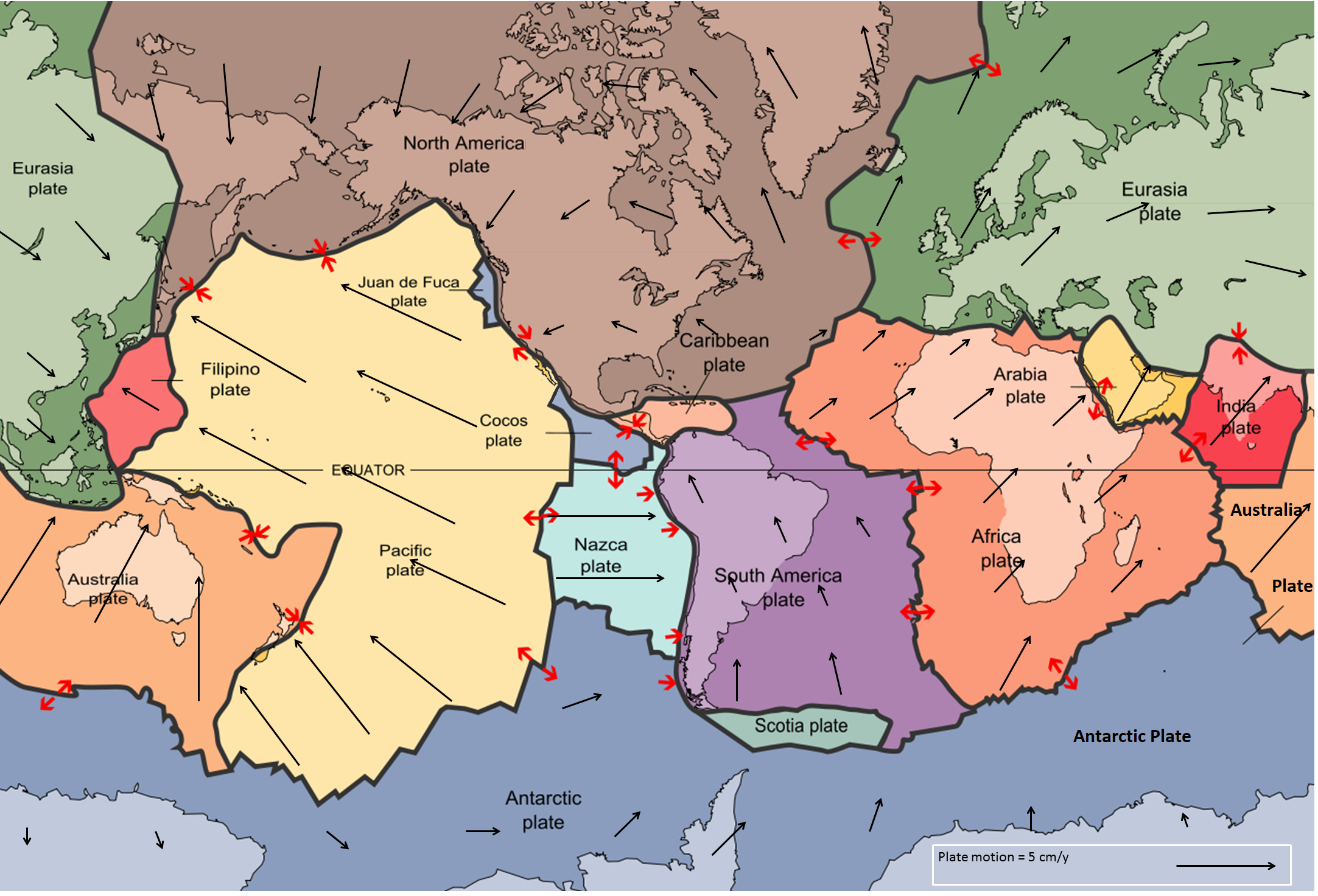
Credit: Physical Geology by Steven Earle is licensed under a Creative Commons Attribution 4.0 International License, except where otherwise noted. - Identify the location of your community.
- In your notebook, record the name of the plate your community lies within. Record the name of a plate next to your community.
-
The RPM calculator determines how fast your plate is moving relative to another plate that is assumed to be “fixed” (non-moving). At the web site, enter the following information:
- The latitude and longitude of your community
- The name of the plate on which your community is located.
- The name of the “fixed” reference plate adjacent to your plate. Use the African Plate as the reference plate.
-
Once you have entered the data, run the model. Print the results. (Examine the following sample printout for the location of station WES2.) Record the following information in your notebook:
-
The rate of movement of the plate on which your community is located (in centimeters per year).
-
Its direction of motion. (Note that direction is given in degrees, starting from 0°, clockwise from north. For example, 90° is directly east, 180° is directly south and 270° is directly west.)
-
In your own words, describe the motion of your plate over time.
-
How do the results from the computer model compare to those obtained from GPS data?
-
What data does GPS provide that the plate motion calculator does not?
Sample Printout for WES2:
NUVEL-1A Calculation Results
Calculation results are as follows:Relatively fixed plate = Africa
Relatively moving plate = North America
Latitude of Euler pole = 78.8 degree
Longitude of Euler pole = 38.3 degree
Angular velocity = 0.24 degree/million years
Latitude inputted = 42.364799 degree
Longitude inputted = -71.293503 degree
Velocity = 2.11 cm
Direction = 283.39 degree
-
Inquiring Further
To learn more about how GPS works, visit the following web sites:
GPS: A New Constellation, Smithsonian National Air and Space Museum
Explores scientific methods before and after the advent of GPS, as well as a review of how GPS works and its applications.
Understanding Plate Motions, USGS
Reviews the basics of plate motions and introduces the science of geodesy and using GPS to track current plate movements. Includes an image of a GPS satellite.
To learn more about the interior of the Earth and plate motion, visit the following web sites:
“The Interior of the Earth” by E.C. Roberston, USGS
Information about the composition of the crust, the mantle, and the core, and how each was “discovered” and studied.
Tectonic Plate Motion, Space Geodesy, NASA Describes the results of over 15 years of laser tracking data acquired by a network of globally distributed satellite laser ranging sites.
Plate Motion Calculator, UNAVCO
Calculate tectonic plate motion at any location on Earth using one or more plate motion models.
Before GPS How Did We Know the Plates Were Moving? IRIS
The second page of this online document bridges the gap between new technology and the time of Alfred Wegener. Page four describes the use of GPS to study earthquakes and volcanoes.
Section 3: What Drives the Plates?
Learning Outcomes
- Plan and carry out an investigation that determines the densities of various liquids and how this affects their position in a column of liquids.
- Plan and carry out an investigation that determines the densities of various rock samples.
- Apply evidence of the effects of density on the position of materials to provide an explanation for Earth’s layered structure.
- Use a model of natural heat flow from within Earth to identify the effects of uneven heating in Earth’s mantle.
Inquiring Further
To learn more about the driving forces behind plate tectonics, visit the following web sites:
“What Drives the Plates?”, This Dynamic Earth, USGS
Reviews the theories behind convection cells as the driving force of plate tectonics and also takes a look as to whether these mechanisms operate now, or in the past, on other planets.
Plate Tectonics: The Mechanism, Museum of Paleontology, University of California at Berkeley
Describes some of the features of plate tectonics.
New Map Exposes Previously Unseen Details of the Seafloor, Scripps Institute of Oceanography Study satellite images that show details of the seafloor that give insight into plate boundaries and seafloor spreading.
To learn more about Evidence for Earth’s Layered Structure, visit the following web sites:
“Earth’s Interior and Plate Tectonics”, R. Hamilton, from Views of the Solar System by C. Hamilton, Los Alamos National Laboratory
Reviews the divisions of the Earth’s interior, including the percentage of the Earth’s mass that each division encompasses, the depth of each division, and their physical properties. Also includes a review of the lithosphere and plate tectonics.
“The Interior of the Earth”, E.C. Robertson, USGS
Information about the make-up of the crust, the mantle, and the core, and how each was “discovered” and studied.
Section 4: Motions and Interactions
Learning Outcomes
- Use models to explain how plates move and interact at plate boundaries.
- Analyze data on a world map that show relative plate motion to classify the types of movement at plate boundaries.
- Analyze and interpret data on world maps that show plate boundaries and plate motion to describe the present and future plate tectonic setting of your community.
- Evaluate evidence collected by scientists that supports the theory of plate tectonics.
Inquiring Further
To learn more about Volcanoes, visit the following web sites:
Cascades Volcano Observatory, USGS
Information on volcanic hazards, activity, history, and monitoring of volcanoes.
Cascades Eruptions During the Past 4000 Years, USGS
Figure showing the eruptions of Cascade volcanoes over the last 4,000 years.
To learn more about Types of Plate Boundaries, visit the following web sites:
Understanding Plate Motions, from This Dynamic Planet, USGS
Reviews the types of plate boundaries and the basics of plate motions.
Types of Plate Boundaries, from This Dynamic Earth, USGS
Artist’s cross section illustrating the main types of plate boundaries.
How Plates Move, Volcano World
Brief overview of the three types of plate motions. Includes good schematic drawings of each type.
Tectonic Plates Teaching Animation, Nautilus Live: Ocean Exploration Trust
Watch an animation and read the main ideas about the cause of sea floor spreading and its effects.
Convergent Plate Boundaries, USGS
Continental vs. ocean crust setting? Explains why plates are subducted at convergent plate boundaries and what happens to them once they are subducted.
Kick ‘Em Jenny, West Indies, Smithsonian Institution’s National Museum of Natural History, Global Volcanism Program
Kick ‘Em Jenny and Kick ‘Em Jack are the names of two volcanoes in the Caribbean Sea north of Grenada. Learn how the collision of two oceanic plates can create areas of intense volcanic activity.
Section 5: Boundary Environments
Learning Outcomes
- Use a model to explain the formation of continental and ocean-floor features that result from the movement of Earth’s lithospheric plates.
- Analyze data on a world map that shows the locations of hot spots to determine patterns in hot spot formation.
Learning Activity: Modeling Plate Boundary Environments
- You are now going to use Google Earth to examine the distribution of Earth’s plate boundary environments. In Section 1, you saved the file “eqs7day-age.” to your computer. The file contains earthquake location and plate boundary data provided by the United States Geological Survey. Click on the file and it will open up with Google Earth.
- In the Google Earth sidebar, switch off (uncheck) the option for displaying “Earthquake Epicenters” and “Plate Boundaries.”
- Select the “Continental convergent boundary” data to activate it. Using the Google Earth navigation controls, rotate the Earth to view all of the locations for this type of plate boundary. Switch off (uncheck) the data.
- Examine the locations for each type of boundary listed in the sidebar in the same manner as you did in step 3.
- Identify on a world map of lithospheric plates one example of each of the plate boundaries listed in the sidebar.
- With your group, select one of the following plate boundary environments:
- Continental convergent boundary
- Continental rift boundary
- Continental transform fault
- Oceanic convergent boundary
- Oceanic spreading rift
- Oceanic transform fault
- Develop a model that represents your plate boundary environment. Use the information in the Digging Deeper of Section 5 to help you build your model. Make sure your model demonstrates the movements of lithospheric plates and the surface features they cause.
- Share your model with your class.
Inquiring Further
To learn more about life at hydrothermal vents and mid-ocean ridges, visit the following web sites:
Black Smokers, American Museum of Natural History
Learn about black smokers and where they form. Includes images and information about life forms at hydrothermal deep sea vents.
The Deep Ocean Floor, American Museum of Natural History
Learn how much of the ocean floor has been mapped and how new data is being collected.
Exploring the deep ocean floor: Hot springs and strange creatures, USGS
ooks at geothermal vent ecosystems. Contains several photos of the strange creatures which inhabit the far reaches of the ocean floor.
Dive and Discover, Woods Hole Oceanographic Institution
Includes information about the unique geology, chemistry and biology of hydrothermal vents.
Earth - Ocean Interactions Program, NOAA and Pacific Marine Environmental Lab
In-depth descriptions of hydrothermal vents and their unique ecosystems where chemical energy nurtures life instead of sunlight.
To learn more about ocean floor features, visit the following web sites:
Basic Geology of the Mariana Islands, Volcano World
The subduction of the Philippine plate below the Pacific plate has formed the Mariana trench, the deepest oceanic trench in the world. Read about the geology of this area. Also find links to the volcanoes which form at this subduction zone.
Mount St. Helens Volcano, Washington, USGS
Volcanoes formed at subduction zones (convergent plate boundaries) are called composite cone volcanoes. Learn more about composite cones at this site.
Mount Pinatubo, Philippines, USGS
Composite cone volcanoes formed above subduction zones often erupt violently. Learn more about composite cones at this site.
Cascade Range Volcanoes and Volcanics, USGS
The Cascade Range in the Western United States is an example of active subduction volcanism. Follow Cascade Range volcanic activity through a weekly update. This site also provides an in-depth review of the geologic history of the Cascade volcanoes.
Volcanoes in Africa, Smithsonian Institute
Africa is one of the top five volcanic regions in world in terms of numbers of people living within distances of 5-100 km of a volcano. Learn more about the volcanic fields, rifts and and calderas in this dynamic region.
Collision and the Uplift of the Himalayas, USGS
About 225 million years ago India was a large island off the coast of Australia. From 40 million years ago it began to collide with Asia to form the greatest mountain range on Earth. Find out more about the formation of the Himalaya Mountains.
To learn more about hot spots, visit the following web sites:
Hot Spots, NPS
View a slide show with color photos and descriptions about the theory of “hot spots.” Site also includes a list of sample lesson plans, key concepts, references, and activities about hot spots and the Hawaiian islands.
“Hot spots:” Mantle Thermal Plumes, USGS
Learn more about the geology of the Hawaiian islands as well as other hot spots around the world.
Rifting in the Red Sea, East Africa, USGS
A basic map showing the historically active volcanoes in the Afar Triangle. This is a triple junction (or triple point), where three plates are pulling away from one another: the Arabian Plate, and the two parts of the African Plate (the Nubian and the Somalian) splitting along the East African Rift Zone.
Hawaiian Volcanoes, USGS Hawaii Volcano Observatory
Read about the active Hawaiian Volcanoes and how they continue to form above a hot spot. It also includes links to other pages about specific volcanoes on the islands of Hawaii and Maui.
Hotspot Lesson, housed on SERC, Scripps Institution of Oceanography
A high school lesson with presentation materials and a graphing activity for students to explain activity at real-world hotspots.
To learn more about earthquakes and plate tectonics, visit the following web sites:
Earthquake Topics - Plate Tectonics, USGS
Explains the distribution of earthquakes around the globe. Includes a review of plate tectonic theory and the four types of seismic zones. Also includes examples of each type of seismic zone.
Plate Tectonics and Real Time Earthquakes, IRIS
View current and past earthquakes around the globe. Use the zoom tool to see a particular region in detail.
Section 6: The Changing Geography of Your Community
Learning Outcomes
- Analyze data on minerals, rock formations, and fossils on a map of Earth’s continents to determine their distributions.
- Use a model of Earth’s continents to explain changes in the positions of the continents from 250 million years ago.
- Use a model of Earth’s continents to predict changes in the positions of the continents 250 million years in the future.
- Evaluate the evidence for competing arguments for the movement of Earth’s continents over geologic time.
Inquiring Further
To learn more about the development of Plate Tectonics Theory, visit the following web sites:
Plate Tectonics: The Rocky History of an Idea, Museum of Paleontology, University of California at Berkeley
Reviews the development of plate tectonics theory by the late, great Alfred Wegener.
Developing the Theory, from This Dynamic Earth, USGS
Reviews the major scientific developments that spurred the formulation of the plate tectonics theory.
Harry Hammond Hess, from This Dynamic Earth, USGS
Read about the man who developed ideas to support the concept of plate tectonics and what eventually became known as “sea floor spreading.”
Our Changing Continent, USGS
Looks at the clues paleogeographers have used to determine the positions of the continents back through time. Many of these clues were used to initially validate the theory of plate tectonics.
To learn more about geomagnetism and paleomagnetism, visit the following web sites:
Paleomagnetism, Earth Rocks!
A video that reviews the basics of paleomagnetics and how scientists measure the magnetic field of the Earth.
Paleomagnetic Analyses, USGS
Click on the links to learn about the scientific applications of paleomagnetism in rocks and the equipment used for investigation.
Geomagnetism Frequently Asked Questions, NOAA
Describes the use of geomagnetism and provides helpful links to other sites for more information.
Map of Earth’s Magnetic Field Intensity, NOAA
Examine a global map showing how the strength of Earth’s magnetic field varies from the equator to the poles.
Section 7: Volcanic Landforms
Learning Outcomes
- Develop a model and a topographic map of a volcano.
- Analyze contour data on topographic maps to identify volcanic landforms.
- Identify cause and effect relationships between magma composition and types of volcanoes.
Inquiring Further
To learn more about maps, visit the following web sites:
Topographic Map Symbols, USGS
Read more about topographic maps, view and learn what different symbols mean, and find out how maps can be purchased.
Digital Elevation Model, USGS
Learn how lasers can be used to scan volcanoes to measure the elevation of the ground surface and generate very high-resolution models. Unlike photographic methods, the lasers are able to travel through tree canopy to the ground to reveal features of the earth’s surface that are obscured by vegetation.
Cascade Volcanoes from Lewis and Clark’s Expedition, USGS
Select among Mt. Adams, Mt. Hood, Mt. Jefferson, Mt. Rainier, and Mt. St Helens, then scroll down to the images section to find a topographic map.
To learn more about magma composition, visit the following web sites:
Magma Composition, USGS
Find out more about how the chemical composition of magma varies in igneous rocks. The discussion is not limited to just extrusive rocks, but includes intrusive rocks as well.
Magma and Rocks FAQs, Volcano World from the University of Oregon
How does texture and composition relate to igneous rocks? Find out here.
To learn more about volcanic landforms, visit the following web sites:
Types of Volcanoes, Volcano World
An index page with links to short descriptions about different volcanic landforms. This site describes the limitations of thinking about only a few kinds of volcanic landforms.
Principal Types of Volcanoes, USGS
Read a more detailed description of the main types of volcanoes. Text includes pictures for each example (but are all in black and white).
Section 8: Volcanic Hazards
Learning Outcomes
- Use a model that explores the relationship between the volume and surface area of a lava flow.
- Plan and carry out investigations that examine factors that affect lava flows.
- Analyze data from a computer model that simulates mudflows from a volcanic eruption.
- Gather information about volcanic hazards associated with various kinds of flows.
Inquiring Further
To learn more about the Columbia River Basalt Group in the Northwest, visit the following web sites:
Columbia River Basalt Group, CVO USGS
Background information, descriptions, and maps of the Columbia River Basalt Group.
Columbia Plateau Features, Volcano World Oregon State
The Columbia River Flood Basalt Province forms a plateau of 164,000 square kilometers between the Cascade Range and the Rocky Mountains. Read about its formation and how it compares to flood basalts in other parts of the world.
Volcano World, Oregon State University
Identify volcanoes by name or region and find images and information about past eruptions.
Earth - Ocean Interactions Program, NOAA and Pacific Marine Environmental Lab
In-depth descriptions of hydrothermal vents and their unique ecosystems where chemical energy nurtures life instead of sunlight.
To learn more about what happens when lava erupts beneath glaciers and snow, visit the following web sites:
Mount Rainier, Washington, USGS
Information on the eruptions of Mt. Rainier.
Bardarbunga/Grimsvötn Volcanoes, Iceland, Michigan Technological University
Includes location data and reports on volcano activity.
To learn more about lava, visit the following web sites:
Lava Flows, Volcano World Oregon State View a slide show of different forms of lava with color photos and descriptions of each type. Site also includes a list of references and activities about lava.
Magma, Lava, Lava Flows, Lava Lakes, etc., USGS
Learn more background information about lava and related processes using the USGS glossary.
Types of Lava, ETE
A general overview of lava including a description of how silica and water content varies in different types of lava.
Lava and Water, AquaFeel Maryland
Learn what happens when lava erupts into the air, water, and soft sediment. Includes photographs of different kinds of deposits.
To learn more about pyroclastic flows, visit the following web sites:
Pyroclastic Flows, USGS
Learn how pyroclastic flows and surges form, how they are different, and the hazards they pose to people.
Pyroclastic Flows, Volcano Information Center UCSB
An overview of pyroclastic flows. Includes a discussion of how geologists discovered pyroclastic flows as well as a list of journal and book references about pyroclastic flows.
Pyroclastic Flow, USGS
Definition of a pyroclastic flow from the USGS glossary of volcanic terms.
To learn more about lahars, visit the following web sites:
Debris Flows, USGS
Gives a detailed introduction to lahars including what initiates a lahar flow and the composition of a lahar flow. Provides several historic examples of lahar flows associated with volcanic eruptions.
Volcanic Web Shorts: Debris Flow, USGS
Watch a short video about scientists using different approaches to learn about debris flows.
Cascade Volcanoes Observatory Hazards Maps, USGS CVO
Simplified maps showing the locations of hazards from ash, pyroclastic flows, and lahars.
Considering Sustainability *Fourth Edition
To learn more about resilience to volcanic hazards, visit:
Increasing resilience in earthquake-prone and volcanic regions, University College London
An article on research being conducted to test the resilience of communities living near volcanic hazards, with plans to improve resilience.
Living with volcanoes, British Geological Survey
Read about why people have lived near volcanoes for milennia and the natural resilience of human populations.
Section 9: Volcanoes and the Atmosphere
Learning Outcomes
- Analyze data on volcanic eruptions on maps and graphs to identify patterns in the range in scale of volcanic eruptions.
- Plan and carry out an investigation that measures the amount of dissolved gas in a carbonated beverage.
- Develop a model that illustrates how gases dissolved in magma are released during volcanic eruptions.
- Obtain information about the ways volcanic eruptions can affect humans and global temperatures.
Inquiring Further
To learn more about how scientists create models that examine volcanic ash, visit the following web site:
Volcanic Ash Modeling, National Weather Service NOAA
Examines the dangers of volcanic ash and how scientists monitor the dispersion of volcanic ash.
To learn more about monitoring efforts of the Cascades Volcano Observatory, visit the following web sites:
Cascades Volcano Observatory, CVO USGS
Examine how the Cascades Volcano Observatory intensively monitors restless volcanoes and assesses the hazards threat.
To learn more about particle types, visit the following web sites:
Ash - the Greater Hazard, USGS
Ash is the most frequent and widespread volcanic hazard. Find out more about how it affects lives.
Ash and Tephra Fall, USGS
Find definitions and images of terms from the Volcano Hazards Program Glossary.
Volcanic Air Pollution - A Hazard in Hawaii, USGS
Hawaii serves as a good case study for demonstrating how volcanic particles can spread over a wide range.
Airborne Volcanic Ash - Threat to Aviation, USGS
If the world’s air traffic corridors passes over or downwind of hundreds of volcanoes what is the threat?
Volcanic Ash - Danger to Aircraft in the Northern Pacific, USGS
In 1989-1990, a series of eruptions of the Redoubt Volcano in Alaska threatened airplane traffic throughout northern North America. This site includes several examples of the dangers volcanic eruptions can have on airplanes, even if the airplane is hundreds or even thousands of miles from the volcano.
The Volcanic Explosivity Index, National Park Service
Learn more about the classification system volcanologists use to describe and compare volcanic eruptions.
To learn more about volcanic gases, visit the following web sites:
Volcanic Gases and Earth’s Young Atmosphere, Volcano World
Learn about two theories for the origin of Earth’s atmosphere.
Volcanic Gases, Volcano World
Includes different facts about volcanic gases, including data about gas compositions from different plate margins.
Effects of Volcanic Gases, Volcano Information Center UCSB
Lists the effects of different volcanic gases on the environment, including animals.
Volcano Hazards Fact Sheets, USGS
Index of fact sheets from the Volcano Hazard Program.
To learn move about volcanoes and climate change:
Volcanoes and Climate Change, NASA
This article from NASA’s Distributed Active Archive Center details the effects that large scale eruptions, such as the eruption of Mount Pinatubo, can have on the long-term global climate.
Volcanoes and Earth’s Climate, USGS
Learn how volcanic gases like sulfur dioxide can cause global cooling, while volcanic carbon dioxide has the potential to cause global warming.
Considering Sustainability *Fourth Edition
To learn more about infrastructure and volcanoes, visit:
The Impacts of the Mt. St. Helens Eruption on Infrastructure, USGS
Read about how the 1980 eruption affect infrastructure, water quality, and the power network in the area around Mt. St. Helens.
Volcano Hazards Mitigation, Univeristy of Hawaii, Hilo
Information on how to reduce the impacts of volcanic eruptions on infrastructure and human populations.
To learn more about mitigating carbon dioxide from volcanic eruptions, visit:
Volcanic ash could help reduce CO2 associated with climate change, University of Southampton An article summarizing research on spreading volcanic ash on the seafloor as a means to sequester carbon dioxide.
Hazardous volcanic CO2 diffuse degassing areas – A systematic review on environmental impacts, health, and mitigation strategies, ViVeiros and Silva, published by Science Direct A scientific journal article on mitigation of carbon dioxide diffuse degassing from active volcanoes.
Section 10: Earthquakes
Learning Outcomes
- Use a model that examines the release of energy that results from an earthquake.
- Use a model of seismic waves to compare the different ways that energy from an earthquake travels through Earth.
- Develop an explanation for the movements of rocks in Earth’s interior and surface that are caused by earthquakes.
Inquiring Further
To learn more about how exploration seismologists use seismic waves to study the deep layers of Earth, visit the following web site:
Assessment of Regional Earthquake Hazards, *What are seismic surveys and how much “shaking” do they create?, Utah Geological Survey
Explains how seismic surveys are used for oil and gas exploration.
Seismologist, GSA
Learn more about becoming a seismologist.
Geoscience Careers in the Geosphere, AGI
Descriptions of geoscience careers and how they study the Earth’s
geosphere.
To learn more about earthquakes and seismic waves, visit the following web sites:
Earthquake Topics, USGS
Comprehensive list of topics related to earthquakes. Also, some topics are linked to other sites allowing reader to gain further information.
Frequently Asked Questions, USGS
Covers a wide range of topics to give a good general scientific overview of earthquakes. Also debunks many earthquake myths. Additional links are provided to more information on other websites.
Earthquakes, USGS
This online publication is an excellent overview of earthquakes and includes a lot of good graphics and photos.
What do Seismic Waves Look Like?, Purdue University
Animations of P and S waves, as well as Love waves and Rayleigh waves.
Animations of Earthquake Terms, USGS
From aftershocks to wavefronts, this site will help you to visualize complex processes.
Section 11: Earthquake Waves
Learning Outcomes
- Carry out an investigation of seismic waves by constructing a simple seismometer and measuring device.
- Analyze and interpret seismic data on a seismogram to determine patterns in P wave and S wave travel times.
- Gather information about how seismic waves provide evidence for the structure and composition of Earth’s interior.
Learning with Technology
Shake It Up with Seismographs, Discover Engineering
A classroom activity for students to design their own seismographs.
Inquiring Further
Seismograph Activity
To learn more about the history of earthquake studies, visit:
A Brief History of Seismology to 1910, Institute for Crustal Studies, University of California at Santa Barbara
Read about early explanations for earthquakes and the start of the “modern era” of seismology around 1750. Follow the development of the science of earthquake study.
To learn more about recent seismic activity and how seismic waves travel through the Earth, visit the following web sites:
Latest Earthquakes, USGS
Updated list by date, magnitude, location, and depth. Zoom in and out of map or select region from menu.
Seismic Monitor, IRIS Consortium, University of Washington
Map is updated every 30 minutes - shows locations of earthquakes as well as seismic events on or near nuclear test sites. Also include earthquake news and teachable moments.
Seismometers, Seismographs, and Seismograms, etc., USGS
Use the Earthquake Glossary to see how seismographs work, how P and S waves move and learn to read Travel-Time curves.
To learn more about how seismograms are used to find the distance to an earthquake epicenter, visit the following web sites:
Virtual Earthquake, California State University
Provides an interactive Web-based activity designed to introduce you to the concepts of how an earthquake epicenter is located and how the Richter Magnitude of an earthquake is determined. Also includes other tutorials such as P-S wave lag time.
Epicenter: Determine the Precise Location of the Epicenter of an Earthquake, IRIS
Watch a short video about how to determine the precise location of the epicenter of an earthquake.
To learn more about seismometers, visit the following web sites:
How Do I Read a Seismogram?, USGS
This video will help you learn to read seismograms.
Seismographic Networks Improve Volcano Warnings, USGS
Descriptions of how seismometry is used to monitor volcanic eruptions. Contains good images of technology.
Different Processes: Different Seismic Signals, USGS
Learn how to distinguish the seismic signal from a landslide compared to a glacier sliding or an actual tectonic event.
To learn more about the GRACE-FO satellites and the data they collect, visit: *Fourth Edition
GRACE-FO, NASA Jet Propulsion Laboaratory
The official page for inforamtion on the GRACE-FO satellite missions, data, and interpretations of findings.
Soil Earth, NASA Jet Propulsion Laboratory
How data collected from the GRACE-FO satellites has detected changes in gravity that occurred during earthquake events.
Considering Sustainability *Fourth Edition
To learn more about innovations in how earthquakes are studied, visit:
The Evolution of Earthquake Science, UCLA
An article on how scientists are improving early-warning systems and ways of detecting seismic waves from earthquakes.
Geologists test the use of AI in predicting Earthquakes, The University of Texas
How scientists are using AI to predict when earthquakes will occur.
5 Civil Engineering Innovations That Help Buildings Withstand Earthquakes, Norwich University
A summary of innovations in building design that reduce the imapacts of earthquakes on infrastructure.
Section 12: Earthquake Waves
Learning Outcomes
- Analyze and interpret data from personal observations of the effects of an earthquake to locate an earthquake’s epicenter.
- Examine an online tool used by scientists to collect and analyze data from people’s experiences of an earthquake.
- Obtain information about the extent of the damage caused by earthquakes of different intensities.
Learning Activity: Measurement of Earthquake Wave Amplitude
Visit the Virtual Earthquake website.
a. Follow the directions to calculate the magnitude of the earthquake.
b. How does the amplitude (height) of a seismic wave change when the size of an earthquake changes?
c. How would you expect the amplitude as recorded on a seismogram to change as you get farther from the epicenter?
Build an Earthquake-Resistant Structure, Discover Engineering A classroom activity to test the resilience of structures during simulated earthquakes.
Inquiring Further
To learn more about detecting and recording earthquakes, visit the following web sites:
Did You Feel It?, USGS
Take part in citizen science by sharing your intensity observations for an earthquake you experienced.
Earthquakes and Seismicity - Magnitude vs Intensity, USGS
Describes the energy released by an earthquake. Includes a good explanation of the difference between magnitude and intensity.
Earthquake Intensity Database 1638 - 1985, NOAA
Includes an earthquake intensity location map of North America. Allows searches for specific earthquakes by city and state, so you can look up the intensity of historic earthquakes in your community.
Global Seismographic Network, USGS
Description of the Global Seismic Network (GSN) and how it is used to study earthquakes around the world.
Monitoring Earthquakes Across the United States, USGS
Brief description of how seismograph networks are used to monitor earthquakes across the country.
Seismometers, Seismographs, and Seismograms, etc., USGS
Use the Earthquake Glossary to see how seismographs work, how P and S waves move and learn to read Travel-Time curves.
To learn more about tsunami detection in the Pacific, visit the following web sites:
Local Tsunamis in the Pacific Northwest, USGS
History of local tsunamis, including geological evidence and legends surrounding these giant waves.
Tsunami Hazards, University of the West Indies
Factors that affect a tsunami’s strength.
Tsunami Resources and Links, NOAA
Multiple topics concerning tsunamis to chose among. Including video of simulations such as the Alaska earthquake of 1964.
The 2004 Sumatra Quake and Tsunami, IRIS
Visualization of the propagation of the earthquake waves showing record of waves arriving at different monitoring stations.
Earth/Space Sciences at Work *Fourth Edition
To learn more about each career and its connections to Earth Science knowledge and work toward the SDGs, visit:
Atmosphere: Air Traffic Controller
Air Traffic Controllers, AGI
A brief description of the geoscience knowledge used by air traffic controllers. Includes links with more information on this career.
Weather data used by air traffic controllers, Federal Aviation Administration
A summary of weather conditions, including volcanic eruptions, that are important for air traffic controllers to understand and be able to communicate about.
Biosphere: Insurance Agent
Plate tectonics and people, USGS
Read about how natural hazards associated with earthquakes affect human populations.
How do I decide whether or not to get earthquake insurance?, USGS
A list of factors that people should consider when buying a home in earthquake-prone areas.
Cryosphere: Tour Guide
Tour Guide, AGI
A brief description of the geoscience knowledge used by tour guides. Includes links with more information on this career.
Katla Ice Cave Tour, Iceland with a View
A video of a tour of an ice cave under a volcano in Iceland.
Geosphere: Civil Engineer
Civil Engineer, AGI
A brief description of the geoscience knowledge used by civil engineers. Includes links with more information on this career.
The role of civil engineering during natural disasters, McNeil Engineering
Read about the work of civil engineers that helps increase resiliency in the face of natural disasters related to plate tectonics.
Hydrosphere: Harbor Master
Tsunamis! What Boaters Should Know, California Department of Conservation
Advice on how to handle a tsunami while on a boat, particularly if it is near a harbor or shoreline.
Harbor Damage after an Earthquake, Hawaii Department of Transportation
An official notice from a Harbor Master assessing damage after an earthquake in Hawaii.