
Back to the AGI Connections Index
AGI Connections - Winter 2025
Explore AGI Federation Activities in the Latest Issue of AGI Connections
The newsletter highlights AGI news and upcoming events from across the geoscience federation. Help us share important geoscience events by contacting Geoff Camphire, AGI Communications.
Please take the Reader Survey: Help us to continue improving this newsletter by taking less than five minutes to complete the brief AGI Connections Reader Survey. Thank you for your input!
In This Issue
- New Report on Benefits of Geological Mapping Hailed
- Partnership with NRCS Explores Soils, Illuminates Possibilities
- Geological Surveys Database Unlocks a Century of Geoscience
- Geoscience Caucus Channels Leaders’ Candid Conversations
- New From AGI
- Geoscience Event Calendar
- Take the Reader Survey
New Report on Benefits of Geological Mapping Hailed

Geoscience leaders are applauding a groundbreaking new study published by AGI and edited by Richard Berg (Illinois State University) and James Faulds (Nevada Bureau of Mines & Geology) that proves what geoscientists have long known: investing in geological mapping delivers massive returns for society. The landmark report, Economic Analysis of the Costs and Benefits of Geological Mapping in the United States of America from 1994 to 2019, provides the first nationwide economic analysis of geological mapping. Its findings are striking: for every dollar invested, geological mapping has delivered 7 to 10 times in benefits ― and in some cases, as much as 35 times.
For those in industry, this is no surprise. “Public geoscience data like EarthMRI surveys make exploration more efficient ― reducing both financial risk and environmental disturbance. For mineral exploration companies like ours, that’s a game-changer,” says Scott Petsel, President of Metallic Minerals. Petsel emphasizes that enhanced mapping helped his company more effectively guide exploration in Colorado, saving costs, reducing risks, and lowering environmental impact.
Geoscientists in the public sector likewise recognize the crucial importance of this research. “Because groundwater aquifers are its sole source of drinking water, McHenry County, Illinois, has invested in 3-dimensional geological mapping through the Illinois State Geological Survey,” says Scott Kuykendall, Water Resources Specialist of McHenry County. “This geological mapping has been vital to improving the regions understanding of its groundwater aquifers, the recharge potential of the aquifers, and potential risks to supply. Perhaps most importantly, the visualization of subsurface geology is invaluable as an educational tool to help elected officials and the public understand the hidden complexities of groundwater. The value of this geologic mapping was recently demonstrated when the mapping was used to alert a local municipality of risks to its water supply from unsustainable drawdown caused by irrigation pumping that was observed in a shared sand and gravel aquifer.”
Geological maps, produced by state geological surveys and the U.S. Geological Survey (USGS), are far more than scientific charts. They are essential public resources that influence decisions across nearly every sector. They provide vital insights into the Earth’s surface and near-surface layers ― revealing the composition, structure, and history of rocks and sediments. This knowledge forms the foundation for smarter, safer, and more sustainable decision-making regarding natural resources (e.g., critical minerals, groundwater, and geothermal energy) and geologic hazards (e.g., earthquakes, landslides, floods, and sinkholes).
The report surveyed nearly 5,000 stakeholders across all 50 states and confirms that geological maps drive innovation, safeguard communities, and protect resources. Their applications are wide-ranging: supporting construction and infrastructure development, mitigating natural hazards like earthquakes and floods, guiding mineral and water exploration, enhancing public safety, improving land-use planning, and strengthening environmental stewardship. “People don’t often realize it, but geological maps influence their lives every day ― from the safety of the ground beneath their homes, to the quality of their drinking water, to the minerals and energy that power our economy,” says Petsel. “They are the unseen foundation of modern society.”
The economic analysis puts numbers behind these impacts: With $1.99 billion invested in geological mapping between 1994 and 2019 (in 2020 dollars), the study estimates $13.9 billion to $20.6 billion in total economic benefits, analyzed via four different approaches. Moreover, the report shows how benefits extend across multiple sectors, including construction, real estate, mining, energy, infrastructure, transportation, environmental protection, public policy, and disaster response.
“This study puts real numbers to what many of us in the geosciences have long understood ― geological maps are not just scientific tools; they are essential public infrastructure,” Petsel notes. “For policymakers, these maps are a roadmap for safer communities, smarter land-use planning, and more responsible development of the resources we all rely on.”
The study was co-led by the Nevada Bureau of Mines and Geology at the University of Nevada, Reno, and the Illinois State Geological Survey at the University of Illinois, Urbana-Champaign, with funding provided by the USGS (Award No. G19AC00417). The project included a steering committee of Association of American State Geologists members and a former USGS economist as well as participation from the American Institute of Professional Geologists, and AGI. The National Academy of Sciences coordinated professional feedback. AGI also provided editorial and production support.
Read and download the report online. To learn more about this and similar efforts, contact AGI Geoscience Profession and Higher Education Director Christopher Keane.
Partnership with NRCS Explores Soils, Illuminates Possibilities
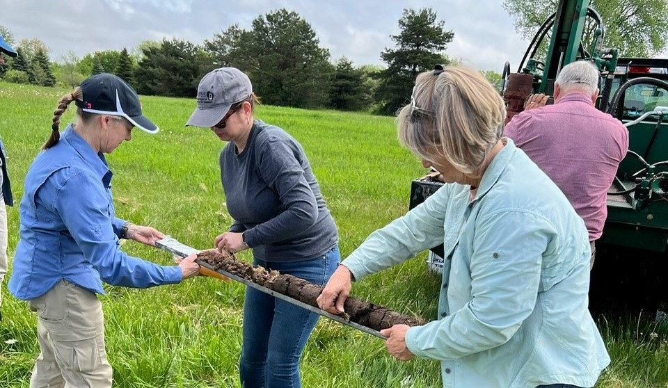
The AGI Education & Outreach Department and the U.S. Department of Agriculture’s Natural Resources Conservation Service (NRCS) are transforming the way teachers and students connect with the science of soils. What began in 2022 with a simple collaboration on an Earth Science Week poster has blossomed into a national partnership, bringing fresh energy and resources to classrooms and empowering educators to reveal the vital role soils play in Earth’s systems.
“Soils are part of the foundation of life on this planet, yet most people are really disconnected from that,” explains Cory Christine Owens, Associate Director of NRCS’s Soil Services and Information Branch and AGI’s main partner at the agency. “Expanding the reach of soil science education creates citizens who can see those connections and make choices that improve the natural world.”
This partnership is doing just that. Together, AGI and NRCS have built a suite of programs designed to immerse teachers in soil science through real-world experiences and classroom-ready tools. At the first Soil Science Workshop launched in 2024 at the University of Wisconsin-Platteville, middle and high school teachers rolled up their sleeves and worked alongside soil experts as they made soil observations at local field sites and analyzed samples in the lab. Similarly, the Teacher Field Experience program, piloted in Crystal Lake, Illinois, gave educators a chance to collaborate directly with NRCS scientists in the field - and then translate those experiences into curriculum-ready lessons for their students. With these programs continuing in 2025 and planned for 2026, demand is growing.
Virtual learning has also expanded access. Through the Virtual Field Experiences, educators can explore the soils of Wisconsin’s Driftless Region and around Corvallis, Oregon, without leaving their classrooms. By coupling immersive digital tools with hands-on activities, AGI and NRCS ensure that teachers across the country can engage with soil science, regardless of geography or school budgets. Equally transformative has been the introduction of educator guides for NRCS’s Web Soil Survey, a comprehensive national database. These guides make soil science approachable for teachers, linking soils to climate change (available online now), with guides on topics such as water resources and natural hazards (coming in the future). In addition, AGI and NRCS are partnering with the Soil Science Society of America (SSSA) to share resources in a free online seminar, Soils in the Classroom. Together, these free resources empower teachers to integrate soils in meaningful ways that highlight the subject’s importance to the environment and society. By incorporating local soils data, teachers can help students connect scientific evidence about soils to their own communities, thereby enhancing the impact of learning.
AGI and NRCS share a vision of a future where students understand soils not as background but as a vital piece of Earth’s systems. “NRCS’s vision is a world of clean and abundant water, healthy soils, resilient landscapes, and thriving agricultural communities through voluntary conservation,” says Owens. “Collaborating with AGI amplifies the reach of this vision and introduces the work we do with America’s farmers, ranchers, and foresters to new audiences. The more people understand America’s vital natural resources and the work of USDA and the NRCS to conserve them, the more we can all work together to achieve that vision.”
From classrooms to conference presentations, the momentum is building. Workshops, field programs, guides, and resources ― including those created by AGI and/or accessed from other high-quality sources such as SSSA ― are drawing teachers into the world of soils while showing students how science connects to their daily lives. AGI is now inviting scientists, educators, and organizations to join this growing movement, whether by supporting teachers in field-based programs, developing new educational tools, or helping to promote awareness of soil science.
This collaboration illustrates AGI’s capacity to work with other prospective partners to advance their aims for geoscience education. Working with partners such as NRCS, AGI staff strive to understand and flexibly respond to partners’ goals by building creative approaches that connect educators with geoscience professionals and real-world data.
Learn more online about the AGI & NRCS Collaboration and additional programs of AGI Education and Outreach. To discuss how AGI can support your organization’s education efforts, contact AGI Education and Outreach Director Ed Robeck.
Geological Surveys Database Unlocks a Century of Geoscience

AGI’s Geological Surveys Database has become a cornerstone of geoscience research, offering a one-stop destination for discovering and accessing tens of thousands of geological publications. What once might have required piecing together hard-to-find documents from scattered sources is now available through a single, searchable platform ― and the impact is growing year by year.
Currently, the database holds more than 59,700 publications, with new additions coming in continually. Contributions vary by state, ranging to more than 4,500 from New Mexico. This expansive coverage ensures that users can uncover not just the latest research but also historic publications dating back to the earliest years of state surveys ― material that might otherwise remain buried and inaccessible through a standard web search.
The numbers reflect just how valuable this resource has become. Last year, the database drew around 31,000 page views, and this year alone it has already seen traffic from 90 countries. While the majority of users come from within the United States, the global reach shows that this collection of U.S. geoscience work is helping to inform scientists and others worldwide.
A collaborative achievement of AGI and the state geological surveys, the database is designed to expand the visibility and use of geological survey publications. It also includes fact sheets from the U.S. Geological Survey (USGS), strengthening the value of the platform as a central hub of trusted geoscience information.
One of the most exciting features of the database is its powerful and flexible search system. Users can run a simple keyword query with the Basic Search, refine their queries with the Advanced Search by selecting multiple fields such as author, title, year, or publication type, or explore with the Geographic Search, which lets researchers zoom into specific regions on a map to discover publications tied to that area. Whether someone is looking for the latest survey on mineral resources, historical records of groundwater studies, or hazard assessments tied to a specific location, the database provides a straightforward path to the right information.
The database evolved from AGI’s Critical Issues Research Database. That early platform offered full-text searching of geoscience-related publications and was soon integrated into the Critical Issues website, creating a seamless space for exploring publications and policy-relevant geoscience content. In June 2017, the newly developed Geological Surveys Database officially launched, building on its predecessor with enhanced functionality and a broader scope. Since then, the focus has been on continually loading publications from across the country, ensuring both current and historic work is preserved and discoverable.
The value of the Geological Surveys Database goes beyond convenience for researchers. By driving more visitors to state geological survey websites and making their publications more visible, the database supports the missions of these surveys to share science that underpins public safety, economic development, and environmental stewardship. From engineers designing infrastructure, to emergency planners assessing natural hazards, to educators building classroom lessons, users across sectors rely on these resources to inform decisions that affect communities and industries alike.
Go online to learn more about the Geological Surveys Database and additional programs of AGI Scholarly Information. For more information, contact AGI Director of Scholarly Information Tia Colvin.
Geoscience Caucus Channels Leaders’ Candid Conversations

Soon after taking the helm at AGI, Executive Director Jonathan Arthur saw a gap: With a federation this large and diverse, meeting only a few times a year through AGI Member Society Council Meetings and the AGI Leadership Forum, the frequency didn’t seem enough to address fast-moving challenges like public perceptions of geoscience, declining university enrollments, and evolving member society needs. Arthur believed there would be value in what he calls “an open conversation about what keeps us up at night.”
Enter the AGI Geoscience Caucus. Launched fall 2022, this informal, leaders-only forum allows geoscience society leaders to meet online to share lessons learned and tackle solutions to problems. Discussions follow the “Chatham House Rule” ― participants are free to share what was discussed, but not who said it or who attended ― which encourages frank, solutions-oriented dialogue.
How does it work? A brief kickoff, including introductory remarks by one or two speakers, sets the stage. Open conversation follows, and high-energy topics sometimes continue into follow-up sessions. Recent discussion topics have included rethinking society models and relevance; membership recruitment, retention, and engagement; broadening and diversifying leadership pipelines; workforce development and the profession’s future; and applications of AI within professional societies.
Attendance averages 25-30 leaders representing more than 20 societies spanning the AGI Federation. The frequency of meetings has increased from just one or two a year at the outset to a meeting every two to three months ― evidence of growing demand and sustained value.
“Because of the participation of so many various leaders from multiple societies across many disciplines, I am grateful that I can hear different perspectives on how other leaders and societies may be handling certain situations or initiatives within their organizations,” says Jim White, Executive Director of the Society of Exploration Geophysicists, who remarks that a recent discussion about artificial intelligence was particularly helpful. “That varied insight provides a platform to make more informed decisions on our behalf. Not that each society may handle their issues the same, it is still good to get a different view on things, and the forum provides that for us.”
“The AGI Caucus is an opportunity to hear the concerns of societies in the geosciences from their perspectives and a chance to combine ideas toward solutions to benefit all,” agrees Angie Anderson, Director of Society Services and Partnerships at GeoScienceWorld, an AGI Liaison Organization. “This has always been GeoScienceWorld’s focus as well and we find the participation in the caucus to be an important resource toward that community sharing.”
To maintain the candid spirit of these conversations, the caucus is invitation-only for the executive directors and presidents (and their designated representatives) of AGI Member Societies, Affiliates, and Liaisons. Want to participate? If your organization is part of the AGI Federation, talk with your society’s executive director or president.
The Geoscience Caucus represents just one of the many benefits of affiliation with our federation of geoscience societies. Visit our AGI Membership Benefits page to learn about other affiliation benefits. For more information, contact AGI Communications Lead Geoff Camphire.
New From AGI
- Read Geoscience Driving Innovation, AGI’s 2024 annual report including audited financial statements for the past three fiscal years. The report offers a comprehensive look at AGI’s innovative efforts to strengthen the geoscience profession, foster effective partnerships, and expand opportunities across the geoscience community.
- Pump up your policy engagement with Critical Needs: Geosciences Meeting the Needs of the Nation, a six-part document series by AGI and its federation of geoscience member societies that shows ways geoscience can support solutions for our nation’s most urgent challenges around economic growth, infrastructure resilience, technological innovation, national security, public safety, and global leadership.
- Check out Economic Analysis of the Costs and Benefits of Geological Mapping in the United States of America from 1994 to 2019, a groundbreaking report that provides an in-depth economic assessment of geological mapping, illuminating the significant return on investment and critical benefits for industry, government, and society.
- Check out the recorded talks of the “Energy Resources for Our Future” Webinar Series, originally aired during Earth Science Week 2025, which explored topics including how to incorporate energy science into education, challenges and opportunities associated with geothermal energy, energy exploration and educational applications, and geologic mapping and modeling.
- AGI’s GRANDE (Geoscience Program Adaptation to Natural Disruptive Events) study has released a wealth of data and results as well as a final report of this multi-year effort to identify established best practices for geoscience academic departments relative to disruptive natural events.
- Monthly geoscience employment data, including updates from the U.S. Census Bureau and U.S. Bureau of Labor Statistics’ Current Population Survey, can be accessed from AGI’s Profession Data dashboard.
- U.S.-based members of AGI Member Societies can access free training in geoscience communication through this Practical Geocommunication course, thanks to generous support from the American Association of Petroleum Geologists Foundation and the Society of Exploration Geophysicists.
- You can still order a 2025 Earth Science Week Toolkit, containing a wealth of resources supporting the Earth Science Week 2025 theme “Energy Resources for Our Future.” Also, while supplies last, you still can get the 2024 Earth Science Week Toolkit, which focuses on “Earth Science Everywhere,” as well as additional resources on topics of interest to educators.
- Webinars hosted by AGI, available for viewing live and on demand, focus on issues essential to the geoscience profession. Recent webinars include “Divining Workforce Trends in an Era of Chaos,” “Building Geoscience Workforce Skills and Awareness in Your Courses and Programs,” “Shaping the Future of Energy Exploration with Geoscience and Innovation,” and “Geologic Mapping and Modeling.”
Geoscience Event Calendar
Explore the online resource designed to help you promote and track events sponsored by geoscience organizations of the AGI Federation: AGI’s Geoscience Event Calendar.
The calendar, available to view for free by anyone, helps conference organizers:
- Avoid scheduling conflicts and promote collaboration.
- Improve allocation of resources ― such as venues, speakers, and volunteers ― by determining when other societies have scheduled events.
- Increase member engagement, as societies can cross-promote each other’s events.
- Provide consistent communication about events with a single source of accurate event information, ensuring that all societies can share and be aware of event details.
- Foster long-term planning of events well in advance, making it easier to secure preferred dates and venues.
Posting events on the calendar is an exclusive benefit of membership in the AGI Federation. Simply contact AGI Communications’ Geoff Camphire at gac@americangeosciences.org for your society’s authorization code to submit an event on the Geoscience Event Calendar.
Please take the Reader Survey
Help us to continue improving this newsletter by taking less than five minutes to complete the brief AGI Connections Reader Survey. Thank you for your input!
Subscribe or Unsubscribe
To receive AGI Connections alerts by email, subscribe now. Unsubscribe at any time. Forward and share with a friend or colleague!