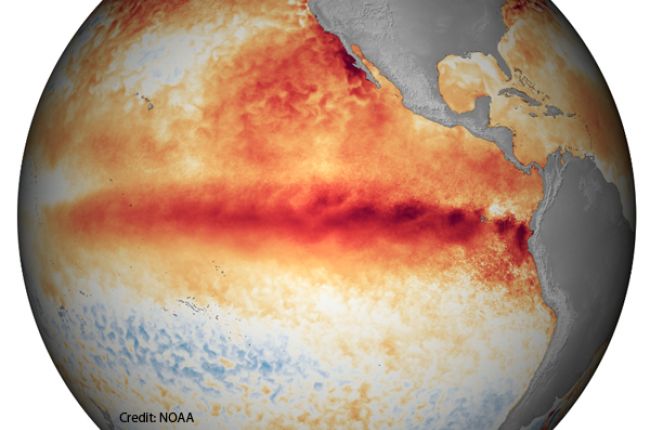
The terms El Niño and La Niña refer to periodic changes in Pacific Ocean sea surface temperatures[1] that have impacts on weather all over the globe. In the Pacific Ocean near the equator, temperatures in the surface ocean are normally very warm in the western Pacific and cool in the eastern Pacific[2]. This helps to generate heavy rains over southeastern Asia and northern Australia and keeps parts of Pacific coastal South America relatively dry[2]. This “normal” pattern of Pacific sea surface temperatures is disrupted periodically by El Niño and La Niña, naturally occurring climate phenomena that occur roughly every 3-7 years[3]. El Niño (the warm phase) and La Niña (the cold phase), typically last for 9-12 months each, but in rare cases can last over multiple years[4].
During El Niño, surface water in the central and eastern equatorial Pacific Ocean is unusually warm[3]. Trade winds[5] blowing from east to west weaken, and the warm surface waters that typically stay in the western Pacific are able to move east along the equator. Rainstorms follow the warm water to the central and eastern Pacific, dry conditions affect northern Australia and southeast Asia, and wetter conditions impact Pacific coastal South America[6]. El Niño can impact U.S. weather by bringing milder conditions to northern areas and wetter conditions to the south, though not every El Niño event affects the U.S. in the same way[6].
La Niña is characterized by the opposite process: the trade winds strengthen, and warm water and rainstorms are pushed to the far western equatorial Pacific over Indonesia[7]. This results in cooler surface water in the equatorial Pacific Ocean, dry conditions in Pacific coastal South America, and much wetter conditions in northern Australia and southeast Asia[7]. La Niña usually impacts U.S. weather by bringing cooler weather to the northwest and warmer weather to the southeast, though just like El Niño, not every La Niña event affects U.S. weather identically[4].
In the U.S., the National Oceanic and Atmospheric Administration (NOAA) declares when an El Niño or La Niña event begins[6]. The National Weather Service provides information on current Pacific conditions[8], as well as historical El Niño /La Niña episodes since 1950.
References
1Sea Surface Temperature National Aeronautics and Space Administration
2Effects of ENSO in the Pacific National Weather Service
3Explaining El Nino National Oceanic and Atmospheric Administration
4What are El Nino and La Nina? National Oceanic and Atmospheric Administration
5Surface Ocean Currents National Aeronautics and Space Administration
6Understanding El Nino National Oceanic and Atmospheric Administration
7Ocean Surface Topography From Space National Aeronautics and Space Administration
8Climate Prediction Center National Oceanic and Atmospheric Administration
Learn More
- How does El Niño affect my area? (Frequent Questions Webpage) AGI Critical Issues Program
- Regional El Niño Impacts and Outlooks Assessments (Website) National Oceanic and Atmospheric Administration
A webpage with a description of the current status of El Niño and links to downloadable regional El Niño Impacts and Outlooks Assessments
- El Niño Portal (Website) National Oceanic and Atmospheric Administration
A portal for information on the current state of El Niño and links to primers and videos about El Niño and La Niña
- Learn More About El Niño/La Niña (Website) National Aeronautics and Space Administration
Basic descriptions of El Niño and La Niña and a wealth links to additional information and images


