Geologic maps provide critical information for coal resource exploration and for planners, regulators, decision makers, and the general public.
Defining the Problem
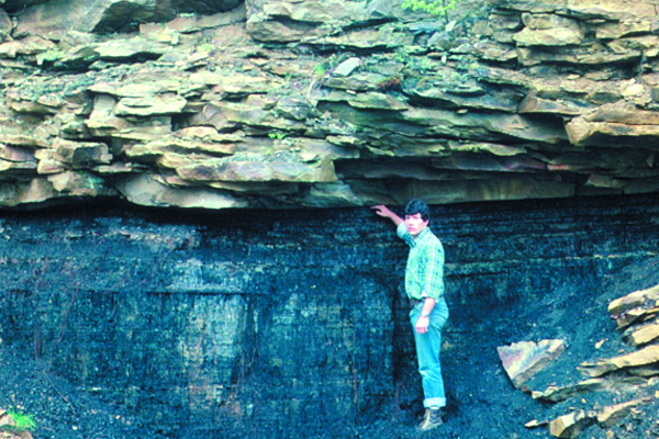
Despite Pennsylvania’s long history as a major coal producer, information on the coal geology (Fig. 1), remaining resources, and extent of past mining is not available for many areas of the state. Such information is critical for present and future coal exploration and development, environmental protection, mine-hazard identification and mitigation, and land-use planning.
Figure 1: Exposure of sandstone capping an economic coal bed. Credit: J. Shaulis, Pennsylvania Geological Survey
The Geologic Map
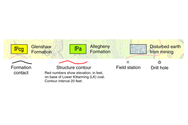
The geologic maps (Figs. 2 & 4) are from a set of 13 maps for the Brandy Camp quadrangle, Elk County, an area in Pennsylvania’s Main Bituminous coal field. The bedrock geologic map (Fig. 2) shows the Allegheny Formation (green), which contains nearly all of the minable coals in the quadrangle, and the Glenshaw Formation (yellow), which rarely contains commercial coals.
The small inset map (Fig. 3) indicates where the economically important Lower Kittanning coal is present or mined throughout the quadrangle and also shows the area of the two maps in Figs. 2 & 4 (green outline). The coal-resource geologic map (Fig. 4) shows where the coal occurs at land surface (coal crop lines) and depicts areas of known mining. Similar resource maps exist for the other 10 commercial coals in the quadrangle.
Figure 2 (top): [1]The bedrock geologic map distinguishes between the surface areas underlain by economic coals and those that are not. [2] Structure contours show the amount and direction the rocks are inclined. Credit: C. Dodge, Pennsylvania Geological Survey.
Key to Figure 2 (below top figure): Credit: C. Dodge, Pennsylvania Geological Survey
Figure 3 (middle): [6] Areas of remaining Lower Kittanning coal. Credit: C. Dodge, Pennsylvania Geological Survey
Figure 4 (bottom): [3] Areas originally occupied by Lower Kittanning coal. [4] Known extent of surface (red) and underground (blue) mining. [5] Locations of mine openings. Inset: Pennsylvania bituminous coal. Credit: C. Dodge, Pennsylvania Geological Survey
Applying the Geologic Map
The maps define the coal geology and coal mining. The locations and areas of past mining are used to estimate remaining coal resources and to assess potential or occurring environmental degradation and mine hazards. In particular, information on underground mines, adits, and shafts helps identify sources of acid mine drainage and causes of land subsidence. Locations of underground-mine boundaries are needed to design barriers to separate future operations from past ones. Such barriers help reduce the risk of cutting into older, abandoned workings.
The elevation of the Lower Kittanning coal can be determined anywhere on the map from the structure contours. These coal elevations may be used to calculate overburden thicknesses for resource estimates and mine planning, to predict mine-pool locations, and to determine mine-water (and groundwater) flow directions. Geologic information from the maps has been used for coal exploration, resource estimation, mine permitting, landfill siting, and acid mine drainage abatement. Based in part on this information, the Pennsylvania Department of Environmental Protection issued a permit to a coal company in early 2003 to operate the first new underground mine in this area in more than four decades.
Conclusion
Geologic maps provide critical information for resource exploration and for planners, regulators, decision makers, and the general public.
Additional Information
Case study author: Clifford H. Dodge (Pennsylvania Geological Survey)
Case study from: Thomas, W.A. 2004. Meeting Challenges with Geologic Maps, p. 52-53. Published by the American Geosciences Institute Environmental Awareness Series. Click here to download the full handbook.

![Fig. 2. [1]The bedrock geologic map distinguishes between the surface areas underlain by economic coals and those that are not. [2] Structure contours show the amount and direction the rocks are inclined. Credit: C. Dodge, Pennsylvania Geological Survey Fig. 2. [1]The bedrock geologic map distinguishes between the surface areas underlain by economic coals and those that are not. [2] Structure contours show the amount and direction the rocks are inclined. Credit: C. Dodge, Pennsylvania Geological Survey](https://www.americangeosciences.org/sites/default/files/critical-issues-images/CI-EA-maps-Pennsylvania-case-study-002-600-400px.jpg)
![Fig. 3. [6] Areas of remaining Lower Kittanning coal. Credit: C. Dodge, Pennsylvania Geological Survey Fig. 3. [6] Areas of remaining Lower Kittanning coal. Credit: C. Dodge, Pennsylvania Geological Survey](https://www.americangeosciences.org/sites/default/files/critical-issues-images/CI-EA-maps-Pennsylvania-case-study-003-600-400px.jpg)
![Fig 4. [3] Areas originally occupied by Lower Kittanning coal. [4] Known extent of surface (red) and underground (blue) mining. [5] Locations of mine openings. Inset: Pennsylvania bituminous coal. Credit: C. Dodge, Pennsylvania Geological Survey Fig 4. [3] Areas originally occupied by Lower Kittanning coal. [4] Known extent of surface (red) and underground (blue) mining. [5] Locations of mine openings. Inset: Pennsylvania bituminous coal. Credit: C. Dodge, Pennsylvania Geological Survey](https://www.americangeosciences.org/sites/default/files/critical-issues-images/CI-EA-maps-Pennsylvania-case-study-004-600-400px.jpg)
