Hazards

Natural hazards such as earthquakes, landslides, hurricanes, floods, and wildfires endanger public health and safety, threaten critical infrastructure, and cost our economy billions of dollars each year. Geoscientists study these hazards to provide information and warnings to populations at risk.

Frequently Asked Questions

National Oceanic and Atmospheric Administration
American Geosciences Institute
U.S. Geological Survey

Case Studies & Factsheets

Cover of AGI Factsheet 2018-002-Geologic Mapping and Public Health

Using Geologic Maps to Protect Public Health Geologic maps can be used to understand and mitigate public health risks across the US, in addition to their more traditional use in resource and infrastructure decisions. Geologic maps can show the location of naturally occurring hazardous materials and...

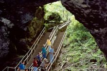
Fig 1. A NPS ranger leads visitors into the mouth of Mammoth Cave National Park, Kentucky.

Geologic maps are being used in Kentucky to identify areas that have high potential for development of karst features, such as sinkholes and caves. Defining the Problem A new interstate highway, I-66, is being planned to pass through the vicinity of Mammoth Cave National Park (Fig. 1). It is one of...
Cover of AGI Factsheet 2018-004 - Present Day Climate Change

Climate Science 101 Climate is the average of weather conditions over several decades.1,2 Geoscientists monitor modern climate conditions (1880 A.D. to present) in part by taking direct measurements of weather data (i.e., air temperature, rainfall and snowfall, wind speed, cloudiness, and so on)...

CI_Factsheet_2017_4_drywellbasics_170906_thumb.JPG

What is a Dry Well? A dry well is a well that is used to transmit surface water underground and is deeper than its width at the surface (see image, below). Most dry wells are 30 to 70 feet deep and 3 feet wide at the surface. They are lined with perforated casings and can be filled with gravel or...

Cover of Induced Seismicity from Oil and Gas Operations

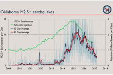
Manmade Earthquakes Any activity that significantly changes the pressure on or fluid content of rocks has the potential to trigger earthquakes. This includes geothermal energy production, water storage in large reservoirs, groundwater extraction, underground injection of water for enhanced oil...
Cover of Geoscientists in Petroleum and the Environment

Introduction Geoscience – the study of the Earth – underpins our understanding of the many intersections between petroleum and the environment, from the search for resources to the study of air pollutants. Without the work of geoscientists, we would have neither the energy system nor the...

CI_Factsheet_2017_5_drywellprograms_170906_thumb.JPG

Introduction Dry wells improve stormwater drainage and aquifer recharge by providing a fast, direct route for rainwater to drain deep into underlying sediment and rock. Dry wells are most common in the western U.S. where clay or caliche layers slow down the natural drainage of water into underlying...

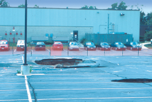
Fig. 1. Sinkholes in collapsed parking area, Frederick, MD. Sinkholes form in carbonate areas as the dissolving and weakening of bedrock cause it to collapse. Credit: D.K. Brezinksi

Although sinkhole development in susceptible areas cannot be completely prevented, policy makers and the public can use geologic maps that delineate karst features to develop strategies that can minimize or avoid property damage and personal injuries. Defining the Problem Sinkholes, which abound in...

Fig. 1. Densely built urban areas on soft soils are prone to earthquake damage. Geologic maps provide vital information on the extent of these soils. Credit: N.J. Department of Environmental Protection

Geologic mapping provides the data foundation that makes soil mapping and earthquake simulations possible. This approach also can be used to predict damage in areas where the historical record indicates a risk of potential earthquakes. Defining the Problem The density and value of its buildings...

Cover of AGI Factsheet 2018-003--Using Geologic Maps to Reduce Landslide Risk

Geologic Maps and Landslide Hazards A geologic map is key to understanding landslide risk. The U.S. Geological Survey (USGS) and numerous state geological surveys around the nation prioritize the mapping of landslide-prone areas. Understanding landslide risk is crucial in making decisions around...

CI_Factsheet_2018_1_NewMadrid_180226_thumb.JPG

Earthquakes in the New Madrid Fault Zone The New Madrid fault zone (NMFZ) is a long-established weakness in the Earth’s crust in the central and eastern US where earthquakes have occurred for hundreds of millions of years. In 1811-1812, three large earthquakes (up to magnitude 7.5) caused severe...

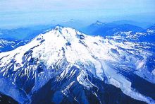
Fig. 1. Although Glacier Peak normally can not be seen from any urban areas, this active volcano periodically erupts in an explosive catastrophic manner that could affect the lower part of the populated Skagit River Valley. Credit: D. Mullineaux, USGS

Surface and subsurface mapping of lahar and lahar runout deposits from Glacier Peak volcano has contributed important geologic information for land-management planning and emergency preparedness in the lower Skagit Valley. Defining the Problem Active volcanoes, such as Glacier Peak (Fig. 1), pose a...

cover of Currents Factsheet 2019-002

Traditional geoscience departments commonly require 60 semester hours of geology and geology-related elective courses to achieve a BA/BS degree. Of the 60 hours, typically half are required courses in geology. Recently, the National Association of State Boards of Geology (ASBOG®) evaluated more...

CI_Factsheet_2017_7_ValleyFever_171205_thumb.JPG

What grows in arid, sandy soils? How do these soils become dust? Many small organisms, such as bacteria and fungi, grow among the sand and silt particles in dry valley and desert soils. At the soil’s surface, these organisms often form biological webs (“microbiotic crusts”) that keep small sand and...

cover of Currents Factsheet 2019-001

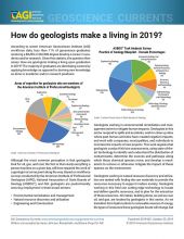
According to recent American Geosciences Institute (AGI) workforce data, less than 11% of geoscience graduates receiving a BA/BS or MA/MS degree develop a career in academia and/or research. Given this statistic, the question then arises: How are geologists making a living upon graduation in 2019?...

CI_CaseStudy_2018_2_RipMapping_Cover.PNG

What is a rip current? Rip currents are fast, concentrated flows of water that can form on beaches that have breaking waves.1 Every beach is different, but rips generally form when waves break across a wide surf zone and the beach bathymetry is uneven (e.g., if there are sandbars, piers, jetties,...

Cover of Subsurface Data in the Oil and Gas Industry

Introduction Drilling for oil and gas is expensive. A single well generally costs $5-8 million onshore and $100-200 million or more in deep water.1 To maximize the chances of drilling a productive well, oil and gas companies collect and study large amounts of information about the Earth’s...

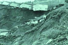
Fig.1. Home in Oakland, CA, destroyed by landslides in 1958. Source: J. Coe, USGS

In California, detailed modern geologic maps are fundamental for evaluating how susceptible an area is to earthquake-induced landslides. Defining the Problem The geologic history of the Oakland, California, area has produced steep hillsides and unstable rock and soil that generate damaging...

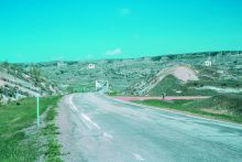
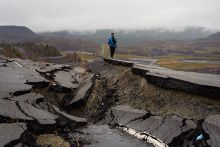
Fig. 3. U.S. Highway 85 crossing the Little Missouri River. Seventy-five percent of the rocks in this photograph, all of those in the foreground and the rocks along the north valley wall in the background have slid and are out of place. Credit: E. Murphy

Geologic maps can help to show which areas may be more prone to landslides and therefore directly assist in making optimum engineering design choices. Defining the Problem U.S Highway 85 and ND Highway 22, along with numerous county roads, buildings, pipelines, and power lines, have been...

CI_CaseStudy_2017_1_VolcanicLandslides_thumb.JPG

More than just volcanic eruptions Volcanic eruptions are a serious hazard. But at many stratovolcanoes in Washington, Oregon, Northern California, and Alaska, landslides and debris flows can be just as dangerous. Some of these - especially volcanic mudflows (lahars) - are directly triggered by...

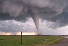
Tornado funnel. Image Credit: NOAA

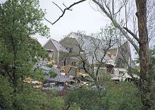
Remote sensing imagery is used by researchers at the University of Wisconsin–Madison to support recovery efforts after a tornado. Defining the Problem Following a tornado, first responders need maps of the width and location (swath) of the damage area. The biggest challenge when integrating remote...

Fig. 1. A 1995 landslide in Overland Park, Kansas, destroyed two homes and damaged four lots. Credit: Kansas Geological Survey

Landslide hazard maps based on geologic maps are a tool for local government officials, planners, developers, engineers, insurance companies, lending institutions, and landowners to assess the risk and take appropriate actions. Defining the Problem Damaging landslides occur even in vertically...

CI_CaseStudy_2018_3_RipsBeachAccess_cover.PNG

What is a rip current? Rip currents are fast, concentrated flows of water that can form on beaches that have breaking waves.1 Every beach is different, but rips generally form when waves are breaking and the underwater surface is uneven (e.g., if there are sandbars, piers, jetties, or groins along...

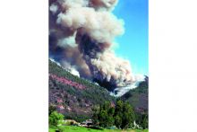
Fig. 1. Homeowners and emergency managers are still coping with debris flows and the aftermath of the 2002 Missionary Ridge wildfire near Durango, CO. Credit: P. Winkworth

Geologic maps are useful in identifying areas that may be affected by post-wildfire debris flows. Land-use planners use these maps to identify potential hazards in areas that are proposed for development and to develop mitigation strategies. The maps can also focus post-wildfire emergency planning...

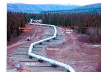
Fig. 3. View of part of the Trans-Alaska Pipeline at the Denali Fault showing major design features. Fault movement and intense ground shaking were accommodated by zigzagging the pipeline and leaving it free to slide. Credit: M. Metz, Anchorage

On November 3, 2002, the 800-mile long Trans-Alaska Pipeline pipeline was able to withstand the largest recorded earthquake for the Denali fault without spilling a drop of oil and with only 3 days shutdown time for inspections. The survival of the pipeline demonstrates the value of combining...

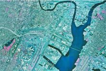
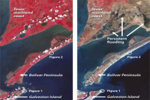
Pre-Ike (left) and post-Ike (right) ASTER imagery of Galveston Island, the Bolívar Peninsula, and the mainland in August 2006. Healthy (red) and dead (brown) vegetation shows storm surge inundation effects. Image Credit: Jesse Allen, NASA Earth Observ.

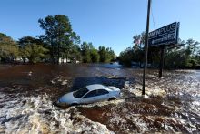
Hurricanes bring not only intense rainfall, but also high winds and flooding. This flooding is powered by the hurricane storm surge: a rise in coastal sea level caused by lowered barometric pressure and by wind blowing the ocean onto the land. The result is that waves and currents affect areas that...

1 of 26

Build Your Knowledge & Skills

Computer on desktop

Expand your learning and build your skills and knowledge with courses on the Geoscience Online Learning Initative's (GOLI) platform. Learners can browse course descriptions, enroll in specific courses, access content, and embed learning into their daily schedules when it is convenient.

...