Modern tools improve risk assessment for volcanic landslides and debris flows
More than just volcanic eruptions
Volcanic eruptions are a serious hazard. But at many stratovolcanoes in Washington, Oregon, Northern California, and Alaska, landslides and debris flows can be just as dangerous. Some of these - especially volcanic mudflows (lahars) - are directly triggered by eruptions, but others are not. Volcanoes are covered with loose debris, ice, and altered rock. Even small changes - melting glaciers, small earthquakes, minor eruptions, or increased hydrothermal activity - can mobilize this material, which may collapse in a landslide or cascade down the volcano’s flanks in a debris flow or lahar.
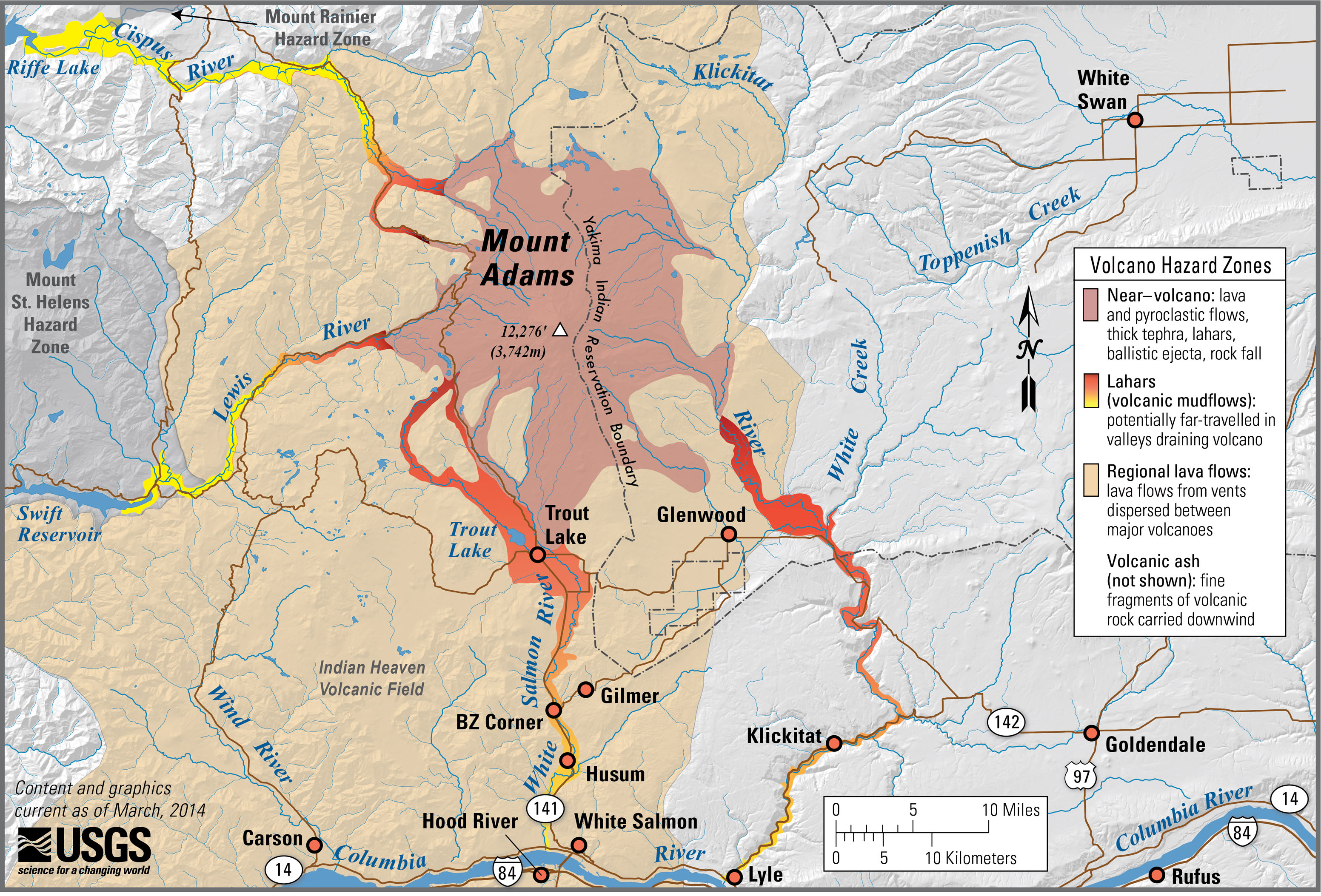
The better we understand the risks, the better we can plan to reduce the impacts of these hazards. Knowing which parts of a volcano are most likely to experience landslides and debris flows allows communities to modify construction plans, evacuation routes, insurance rates, and infrastructure to improve community resilience and preparedness.
Volcanic hazard map of Mt. Adams, Washington. Image credit: Lisa Faust, U.S. Geological Survey
The problem: reliable risk assessments
Historically, landslide hazards have been determined by mapping the surface of volcanoes and past landslides. However, many important risk factors are difficult to accurately determine using these methods. These include the thickness of ice, distribution of groundwater, alteration of rock, and thickness of debris. Traditional ground-based monitoring and surveying can be hazardous on the flanks of volcanoes, where many areas are difficult to access.
The idea: electromagnetic mapping by helicopter
Ice, water, and rocks containing different minerals all have different electric and magnetic properties. High-quality sensors can detect these differences from above. In theory, it is possible to fly a sensor over an area to take electric and magnetic measurements, and use these measurements to create a detailed map of the different materials both at the surface and to depths of several hundred meters or more. This technology is common in the minerals industry, where surveys of large areas are conducted to locate mineral deposits based on their electromagnetic properties.
This technology has recently been adapted to help identify areas of altered rock, ice, and groundwater on (and in) volcanoes. By attaching the appropriate sensors to a helicopter, a large area can be covered in relatively little time. This technique does not suffer the problems of access on the flanks of volcanoes that affect ground-based surveys.
3D model of Mt Adams, WA, showing the degree to which rocks are saturated with water or altered by hydrothermal fluids. Image Credit: U.S. Geological Survey
The idea in action: volcanoes in Washington
Helicopter electromagnetic (HEM) and magnetic data have been used to map three of the largest volcanoes in Washington: Mount Rainier, Mount Adams, and Mount Baker. These 3D maps provide much-needed data including the thickness of ice sheets (important for assessing flood and lahar hazards) and the extent to which rocks have been hydrothermally altered (important for assessing landslide hazards). Some notable findings include:
- Rocks at Mts Rainier, Adams, and Baker are hydrothermally altered to depths of at least several hundred meters, though the extent of this alteration varies in different places on each volcano
- The thickest ice on Mount Baker is on the lower slopes.
- The thickest ice on Mount Adams is on the west side of the summit, making meltwater-induced debris flows more likely on the west flanks.
HEM surveying can be combined with traditional mapping, magnetic modeling, and data gathered on the ground to provide the best assessment of volcanic landslide and debris flow hazards.
At a glance
The issue
- The major hazards at stratovolcanoes like Mt. Rainier, WA, are landslides and debris flows of altered rock, groundwater, and melting ice.
- Until recently, the mapping of high-risk zones has relied on surface observations, but these hazards depend strongly on what lies beneath the surface.
Why does it matter?
- Landslides occur in many areas and debris flows can travel many tens of miles.
- At stake are public safety, homes and businesses, roads, insurance rates, and much more.
The idea
- Measure electrical and magnetic properties of rocks via helicopter to map hydrothermally altered rock, ice, and debris at volcanoes.
The idea in action
- U.S. Geological Survey scientists used helicopter electromagnetic mapping (HEM) and magnetic models to map hydrothermally altered rock, ice, and debris on Mts. Rainier, Baker, and Adams in Washington state.
- The information from these surveys improves hazard assessments.
Key concepts, defined
Hydrothermal alteration: the reaction of hot water with rocks, which often weakens them
Lahar: mudflow caused by the mixing of volcanic ash and debris with rain or melting ice
More Resources
- USGS Volcano Hazards Program
- Cascades Volcano Observatory
- Alaska Volcano Observatory
- Hawaiian Volcano Observatory
- AGI Critical Issues Program - Volcanoes
References
Developing Integrated Methods to Address Complex Resource and Environmental Issues, U.S. Geological Survey

This work is licensed under a Creative Commons Attribution-NonCommercial-NoDerivatives 4.0 International License.
You are free to share or distribute this material for non-commercial purposes as long as it retains this licensing information, and attribution is given to the American Geosciences Institute.


