How coastal decision makers can keep beachgoers away from rip currents
What is a rip current?
Rip currents are fast, concentrated flows of water that can form on beaches that have breaking waves.1 Every beach is different, but rips generally form when waves are breaking and the underwater surface is uneven (e.g., if there are sandbars, piers, jetties, or groins along the beach).
Worldwide, hundreds of people drown in rip currents each year. In Australia and the U.S., lifeguards rescue tens of thousands of people from rips every year, but there are still an average of 21 rip-related fatalities per year in Australia and 100 in the United States.2,3 In Costa Rica, an estimated 51 people drown in rips each year.4
The problem: beach development can steer people towards rip currents
Geophysical processes that generate rip currents may also shape the coast in ways that encourage beach access and development in those areas prone to rip currents. For example, rip currents may form along a beach nestled between cliffs, or in areas where sand dunes are smaller: both are features that make an area attractive for real estate development. As a result, developers may unintentionally steer beach users towards rip-prone areas.5,12 This case study features four beaches where, for different reasons, local development unintentionally increased the exposure of beachgoers to dangerous rip current hazards.
Case 1: Pensacola Beach, Florida, USA
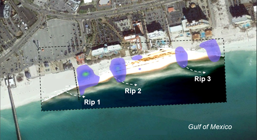
Setting: The shape of the seafloor at Pensacola Beach, Florida, produces semi-permanent rip-currents along the beach. Ridges in the seafloor, spaced roughly a mile apart, focus waves along the ridge crests and produce an alternating pattern of high and low wave energy along the beach (Figure 1).6 This alternating pattern of wave energy shapes the beach from the surf zone to the dunes:
- At the ridges, wave energy is focused and forms larger waves. Because waves begin breaking farther from shore, the beach is wider and sand is blown into tall dunes.7
- Between the ridges, waves are smaller and break closer to shore, keeping the beach narrower, slightly steeper, and wetter, so there is less dry sand that can be blown into dunes. The smaller waves and lowered bathymetry can produce rip currents under the right wave conditions.9
Development: Well-intentioned policy makers and developers built beach access points and hotels in areas with smaller dunes to simplify construction and limit dune disturbance. Unfortunately, because the areas with smaller dunes are also the most prone to rip currents, the beach access points focused beachgoers towards the most rip-prone sections of the beach. Research has since shown that drownings and rescues are more common in these low-dune, rip-prone sections.10
Opportunities: Knowing where rip currents are more likely to form gives developers and coastal planners the opportunity to incorporate mitigation measures, such as constructing walkways and parking lots to guide beachgoers away from rip-prone areas, in designing future developments with rips in mind. Lifeguard presence and signage can be increased in areas prone to rip currents.
In Casino Beach East (part of Pensacola Beach, Florida), beach users cluster (purple-green colors) near popular access points and rip currents (marked with arrows and visible as deeper, darker water breaking through the sandbar). Image credit: Modified from Houser et al. (2015).10
Case 2: Playa Jaco, Costa Rica
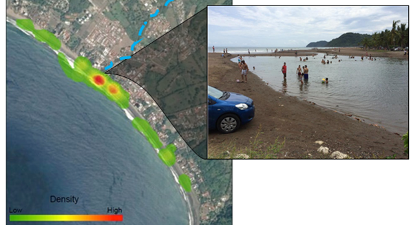
Setting: Playa Jaco (Jaco Beach) is the closest beach to San Jose, the capital of Costa Rica. This is an “embayed” beach, meaning that it is flanked by tall rocky headlands. These headlands affect incoming wave patterns in a way that often creates rip currents.11 At Jaco, there is also a central river that cuts across the beach when the river flow is high and the ocean tide is low. This central river deposits sediments and cobbles just off the shore, forming sand bars that are moved down the beach by wave action. When the waves are strong enough, rip currents form in the breaks between these moving bars. A sand bar near the mouth of the central river is almost always present, producing a semi-permanent rip current near the center of the beach (Figure 2).
Development: The main access point for the beach is next to the central river outlet and the semi-permanent rip current. Despite the presence of warning signs and the only state-funded lifeguard service in the country, there are more drownings at Jaco than at all other beaches in Costa Rica combined.4
Opportunities: As at Pensacola Beach, knowing where rip currents form at Jaco could help to inform and optimize lifeguard positioning. A major parking lot positioned away from this central, rip-prone area could also help to guide beachgoers to less dangerous parts of the beach.
Playa Jaco, Costa Rica. A central river (marked blue on the aerial photo) deposits sediment where it meets the beach, which forms sand bars offshore. The combination of the embayed beach shape and sand bars make the center of the beach the most prone to rip currents (red in the aerial photo, left). This is also the location of the main access point for the beach (right). Image credit: Modified from Trimble and Houser (2018).12
Case 3: Bondi Beach, New South Wales, Australia
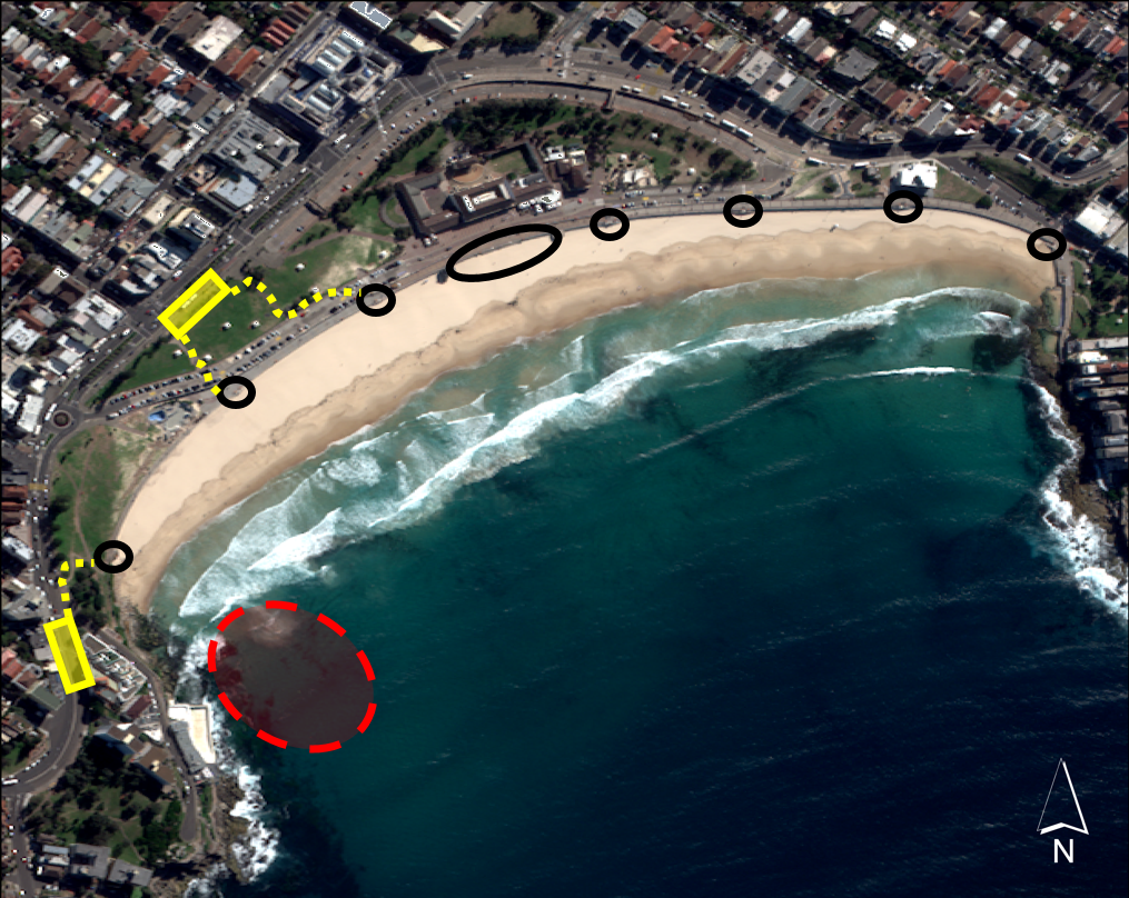
Setting: Bondi Beach is famous in Australia, receiving 1.1 million visitors each year.13 Like Jaco, Bondi is an embayed beach. Its embayed shape, combined with the height and angle of incoming waves, produces one persistent rip current against the southern headland. Depending on the wave conditions, other, smaller rip currents can form every few hundred meters down the rest of the beach. The southernmost current is so constant that it is locally called “Backpackers’ Express,” because travelers are likely to enter at this end of the beach and head directly into the water, unaware of the dangers. Although the world’s oldest beach lifesaving club vigilantly guards this beach, there are still occasional drownings.
Development: The entire beach sits below a sea wall that is approximately 6.6 feet (2 meters) tall. At evenly spaced locations along this wall, ramps provide access down to the sand, while large wide steps provide access to the beach center. These evenly spaced access points do not necessarily focus beach-users towards rip-prone sections of the beach, but there are a number of bus stops, traveler hostels, and restaurants concentrated at the southern end of the beach near the most permanent rip current, bringing more foot traffic to the access points in this vicinity (Figure 3). A popular attraction at the beach is the paved coastal walk from Bondi to other beaches further south. Tourists entering or leaving this walk typically do so at the south end of Bondi beach near “Backpackers’ Express.” Public transit and attractions thereby concentrate non-locals at the more dangerous end of the beach. A recent study has confirmed that the people entering and staying near this end of the beach are more likely to be vulnerable to and unaware of rip currents.13
Opportunities: The strong lifeguard presence and frequent signage already result in many rescues and few fatalities. Moving the bus stops to the northern end of the beach, which is usually safe for swimmers of all levels, could greatly reduce the number of visitors choosing to swim at the dangerous southern end.
Bondi Beach, Sydney, Australia. Headlands on either side of the beach affect incoming waves, generating a regular rip on the southern end of the beach (red area). Black circles are beach access points; yellow areas are bus stops and access paths; dark features just offshore are other rip currents. Image credit: S. Trimble.
Case 4: Galveston Island, Texas, USA
Setting: Galveston Island is a popular tourist destination. A single year can see 5 to 6 million visitors,14 with upwards of 500,000 visitors on popular weekends like Memorial Day or Labor Day.15 Forty percent of drownings here are related to rip currents.16 heavy surf capable of generating strong rips is most common during large storms. More drownings occur in May, when the incidence of large storms and heavy beach use coincide, and specifically between 2 p.m. and 6 p.m., whenever low tide and strong sea breezes combine to produce heavier surf and stronger rip currents.1
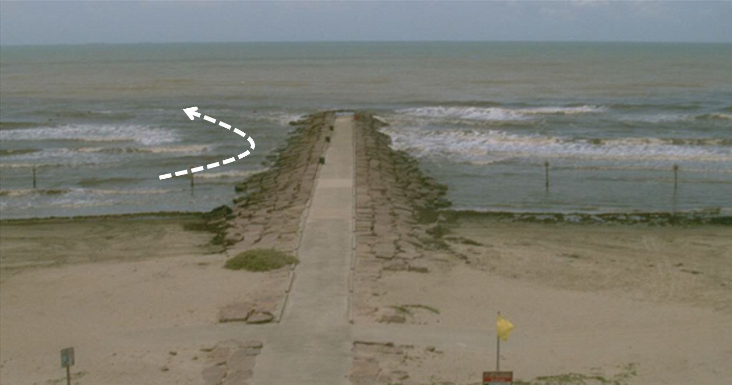
Development: Galveston Island has two distinct beaches: a minimally developed park and a heavily engineered section with a seawall and groins (Figure 4). The groins, built 500 yards apart, help to maintain the beach’s width, but each groin can generate rip currents next to it. Access points on the seawall are located directly behind each groin, depositing beachgoers onto the most hazardous parts of the beach. To reduce the risk to the public, lifeguard stands are located at each groin and “no swimming” zones are marked with signs posted 15 yards on either side of all groins. In the park, where there are no groins, rip formation is less regular, and lifeguard stands are still 500 yards apart. Lifeguards make 100 to 150 rescues on Galveston Island each year. When fatal drownings have occurred, they are commonly outside the guarded areas, and when they have occurred inside the seawall area, they are typically outside of patrol hours.16
Opportunities: As at Bondi, the current lifeguard program already results in more rescues and fewer fatalities. Safety could be further improved by providing beach wall access at safer locations between groins (rather than behind them), and constructing closer-spaced guard towers.
Galveston Island, Texas. Photograph shows a rip current on the left side of a groin. Beach access points are located at the center of each groin, and two signs mark the no swimming zone on each side. Image credit: Modified from Brannstrom et al. (2014).8
The importance of rip currents for development decisions
The risk posed by rip currents can be reduced if authorities account for the exact locations of rips along their beach and post lifeguards and/or build beach access points taking these locations into account. The Centers for Disease Control and Prevention and U.S. Lifesaving Association both provide data demonstrating the effectiveness of lifeguards.17
Towards the future: rip-smart development
Although many beaches in the U.S. currently keep beachgoers safe from rips with a combination of informative signs, red flags to warn of unsafe conditions, and lifeguards, an estimated 100 people still drown each year at U.S. beaches as a result of rip currents.3 Coastal geomorphologists can help to address this issue by providing information on where rip currents are most likely to form, whether they form in the same place or move over time, and the kinds of beach conditions that lead to rip formation. This can help developers, policy makers, and lifeguards to make informed decisions about where to most effectively build beach access points and deploy lifeguard stands, no-swimming zones, and educational information.
At a glance
The issue
- Rip currents can form on most beaches with breaking waves
- In some cases, beach access points favor rip-prone areas
Why it matters
- Swimmers can be pulled away from shore by rip currents, which can be dangerous if a person caught in a rip current does not know how to escape and no lifeguard is present
- Most people do not know how to identify rip currents and/or are unsure of what to do if caught in one8
The idea
- The physical conditions needed for a rip current to form are well understood by coastal geomorphologists
- This knowledge can be used by developers and policy makers to create safer, smarter beach access and development, steering people away from rip-prone areas
Toward the future
- Consulting with a coastal geomorphologist can help developers design safer beach access points
Rip currents, riptides, or undertow?
Most of the time when people use these three terms in conversation they are referring to the same thing: rip currents. “Riptide” is commonly used as a synonym but is not technically correct, because rip currents are not tides. Rip currents are also often incorrectly called “undertow,” which is a technical term in geomorphology that refers to the seaward pull of individual waves just above the sand (easy to remember because it is “under your toes”). Rip currents are sometimes dangerous but natural fast-flowing currents that can form on beaches with breaking waves. For more information on these different terms, see https://www.weather.gov/safety/ripcurrent-science
Key concepts, defined
Bathymetry: underwater surface topography or landscape shape
Groin/groyne: a rigid structure built on shorelines and extending out into the water to limit the amount of sediment/sand transported away from the area.
Learn More
National Weather Service - Rip currents
National Ocean Service - What is a rip current? (video)
Castelle B, Scott T, Brander RW, and McCarroll RJ (2016). Rip current types, circulation and hazard. Earth-Science Reviews, 163, 1-21.
Science of the Surf
References
1 Castelle B, Scott T, Brander RW, and McCarroll RJ (2016). Rip current types, circulation and hazard. Earth-Science Reviews, 163:1-21.
2 Short AD and Hogan CL (1994). Rip currents and beach hazards: their impact on public safety and implications for coastal management. Journal of Coastal Research, SI12:197-209
3 United States Lifesaving Association (2018). Rip Currents (accessed 03 August 2018).
4 Arozarena I, Houser C, Gutierrez-Echeverria A, and Brannstrom C (2015). The rip current hazard in Costa Rica. Natural Hazards, 77(2):753-768.
5 McKay C, Brander RW, and Goff J (2014). Putting tourists in harm’s way – Coastal tourist parks and hazardous unpatrolled surf beaches in New South Wales, Australia. Tourism Management, 45:71-84.
6 Houser C, Hapke C, and Hamilton S (2008). Controls on Coastal Dune Morphology, Shoreline Erosion and Barrier Island Response to Extreme Storms. Geomorphology, 100:223-240.
7 Houser C and Hamilton S (2009). Sensitivity of post-hurricane beach and dune recovery to event frequency. Earth Surface Processes and Landforms, 34:613-628.
8 Brannstrom C, Trimble S, Santos A, Brown HL, and Houser C (2014). Perception of the rip current hazard on Galveston Island and North Padre Island, Texas, USA. Natural Hazards, 72(2):1123-1138.
9 Houser C, Barrett G, and Labude D (2011). Alongshore variation in the rip current hazard at Pensacola Beach, Florida. Natural Hazards, 57:501-523.
10 Houser C, Murphy T, and Labude D (2015). Alongshore correspondence of beach users and rip channels at Pensacola Beach, Florida. Natural Hazards, 78.3:2175:2183.
11 Holman R, Symonds G, Thornton E, and Ranasinghe R (2006). Rip spacing and persistence on an embayed beach. Journal of Geophysical Research: Oceans, 111(C1):C01006
12 Trimble S and Houser C (2018). Seawalls and Signage: How Beach Access Management Affects Rip Current Safety. In: Beach Management Tools - Concepts, Methodologies and Case Studies. Eds. Camilo M. Botero et al. Coastal Research Library, Vol. 24. Springer. ISBN 978-319-58303-7
13 Tourism Research Australia – International Visitors Survey (YE June 2009 to YE June 2014) and National Visitors Survey (YE June 2009 to YE June 2014).
14 Angelou Economics (2008). Galveston Island: tourism economic impact analysis (unpublished report).
15 Rice H (2012). Crowds spell strong finish to Galveston’s tourist season. Houston Chronicle, 4 September.
16 Unpublished data courtesy of Galveston Park Board.
17 Branche CM and Stewart S (2001). Lifeguard Effectiveness: A Report of the Working Group. Atlanta: Centers for Disease Control and Prevention. National Center for Injury Prevention and Control.

