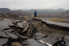
In this webinar, experts from Hexagon and the Arizona Department of Water Resources will discuss the use of time-series displacement maps with a high point density for monitoring and mitigating subsidence due to subsurface extraction of resources such as water or hydrocarbons.
Background
Two related developments have moved the use of radar imagery into the operational realm. The supply of available data has increased greatly, especially with the freely-available Sentinel-1 satellites. And the analysis algorithms are now tested and established, producing reliable and standardized Information Products. One application in particular has benefited greatly from these synergistic developments; centimeter-scale measurement of surface motion on a regional scale. The ability to produce time-series displacement maps with a high point density has revolutionized the monitoring, and mitigation, of subsidence due to subsurface extraction of resources such as water or hydrocarbons.
Our speakers are:
- Derrold Holcomb, Product Manager, Advanced Sensor Software, Hexagon Geospatial |
 Slides |
  Video |
  Application Demo
 - Brian Conway, Geophysics Unit Supervisor, Arizona Department of Water Resources |
 Slides |
  Video
Video
Additional Resources
 View this webinar's Question & Answer session
 Answers to Additional Questions from Webinar Attendees
Media Partners
Thank you to our media partners:
- American Association of Geographers
- American Geophysical Union
- American Institute of Professional Geologists
- Geological Society of America
Media Sponsors
This webinar is generously sponsored by:


