On November 3, 2002, the 800-mile long Trans-Alaska Pipeline pipeline was able to withstand the largest recorded earthquake for the Denali fault without spilling a drop of oil and with only 3 days shutdown time for inspections. The survival of the pipeline demonstrates the value of combining careful geologic studies of earthquake hazards and creative engineering design.
Defining the Problem
The 800-mile long Trans-Alaska Pipeline can carry 2 million barrels of oil per day equal to 17% of the nation’s daily consumption [these data come from the early 2000s; crude oil consumption in 2017 is only slightly lower]. A major earthquake along the Denali Fault where the pipeline crosses the Delta River in the rugged Alaska Range, could cause a potentially catastrophic oil spill.
The Geologic Map
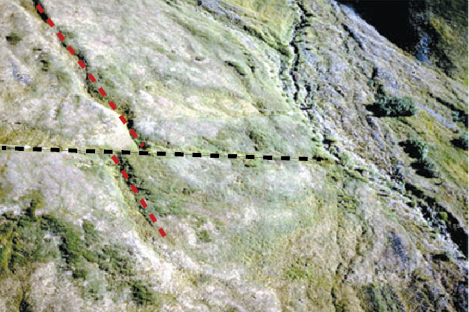
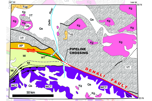
Geologic mapping of bedrock and unconsolidated deposits along the 1,000 mi. extent of the Denali Fault revealed a long and complex history that involved large-scale dominantly horizontal right-lateral slip, as well as local vertical separations (Fig. 1). The geologic map (Fig. 2) shows the distribution of several regional terranes, as well as many local details, along the active fault.
Figure 1 (top): An earthquake offset this drainage (red dashed line) along the Denali Fault (black dashed line) by 26 ft. horizontally and 5 ft. vertically. Sites such as this one provided the data for designing the pipeline fault crossing. Credit: G. Plafker
Figure 2 (bottom): Geologic map of part of the 2002 Denali Fault rupture near the Trans-Alaska Pipeline crossing in the Alaska Range. Note the striking contrast in rock type and age on opposite sides of the fault. Credit: compiled by K. Ridgeway, Purdue University
Applying the Geologic Map
By matching geologic units of known age on opposite sides of the fault, geologists determined that horizontal offset totals about 280 mi. since Early Tertiary time (55-65 million years ago): about 22 mi. since early Oligocene time (38 million years ago); and 98-164 yds. since the late Pleistocene glacial maximum (8,000-12,000 years ago). On the basis of the relative freshness of fault features, it was determined that the eastern 220 mi. of the Denali and Totschunda fault system including the pipeline crossing was the most likely segment to have movement which could generate an 8+ magnitude earthquake.
Conclusion
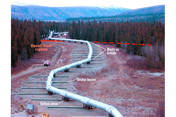
On November 3, 2002, the magnitude 7.9 earthquake generated by movement along the Denali fault and the Totschunda fault was the largest ever recorded in North America from a dominantly strike-slip event. Horizontal and vertical surface fault offsets were as much as 30 and 3.3 ft. respectively, and violent and prolonged shaking triggered thousands of landslides and avalanches. The pipeline remained intact despite ground offset beneath the pipeline of 18 ft. horizontally and 3.3 ft. vertically within a zone about 230 ft. wide, and violent shaking. Survival of the pipeline was a triumph of innovative engineering design that met stringent earthquake design specifications (Fig. 3). The pipeline was able to withstand the largest recorded earthquake for the Denali fault without spilling a drop of oil and with only 3 days shutdown time for inspections. The survival of the pipeline demonstrates the value of combining careful geologic studies of earthquake hazards and creative engineering design.
Figure 3: View of part of the Trans-Alaska Pipeline at the Denali Fault showing major design features. Fault movement and intense ground shaking were accommodated by zigzagging the pipeline and leaving it free to slide. Credit: M. Metz, Anchorage
Additional Information
Case study author: George Plafker (U.S. Geological Survey)
Case study from: Thomas, W.A. 2004. Meeting Challenges with Geologic Maps, p. 56-57. Published by the American Geosciences Institute Environmental Awareness Series. Click here to download the full handbook.


