Geologic maps can help to show which areas may be more prone to landslides and therefore directly assist in making optimum engineering design choices.
Defining the Problem
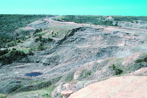
U.S Highway 85 and ND Highway 22, along with numerous county roads, buildings, pipelines, and power lines, have been constructed over existing landslides in the Little Missouri Badlands of western North Dakota. Since 1980, the repair and rerouting of damaged sections of highways in this area have cost taxpayers more than $5 million (Fig 1). In one instance, a one-mile segment of U.S. Highway 85 was rerouted from one area of landslides into another. Better understanding of landslide hazards is needed in this area.
Figure 1: Two recent landslides impacting ND Highway 22 along the south edge of the Little Missouri River Valley. It cost $2 million to stabilize the area and realign the road. Credit: E. Murphy
The Geologic Map
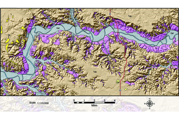
The geologic map encompasses an area of 125 square miles adjacent to the North Unit of Theodore Roosevelt National Park (Fig. 2). In customizing the map for use by design engineers, land planners, and developers, several Quaternary river deposits (gray, Qal), were lumped together to make the landslides (pink, Ql), stand out more clearly. In addition, the geologic units were draped over a shaded-relief background to further emphasize the relationship between the landslides and the surrounding topography.
Figure 2: Landslides are most prevalent along the sides of the Little Missouri River Valley (A), and landslide complexes may extend for more than five miles (B). Credit: Geology by E. Murphy; E. Kadrmas, compiler
Applying the Geologic Map
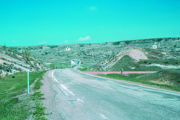
Approximately 37% of the slopes in the badlands in and around the North Unit of the Theodore Roosevelt National Park have failed, and 700 landslides, covering an area of 15,000 acres (6,070 hectares), were identified and mapped in the study area. (Since many of these slides are large complexes, as much as 660 acres (267 hectares) in area, the total number of individual landslides is several times this number.) Most of the landslides are well vegetated, appear relatively stable, and are likely hundreds, if not thousands, of years old (Fig. 3). Without a geologic map showing the location of landslide topography, it is practically impossible for a non-geologist to recognize where there may be a problem. The high percentage of slopes that have failed in this area (1 in 3) demonstrates that the badlands topography is very unstable. Avoiding areas that have already failed will not guarantee that all slope-stability problems will be avoided, but should reduce the number of future impacts.
Figure 3: U.S. Highway 85 crossing the Little Missouri River. Seventy-five percent of the rocks in this photograph, all of those in the foreground and the rocks along the north valley wall in the background have slid and are out of place. Credit: E. Murphy
Conclusion
The high density of unstable lands in this area makes it difficult to avoid siting infrastructure on old landslides. However, if a geologic map is not consulted during the initial planning phase of a project, it is impossible to avoid these problem areas. In general, geologic maps can be expected to delineate controls on landslide occurrence and therefore directly assist in making optimum engineering design choices.
Additional Information
Case study author: Edward C. Murphy (North Dakota Geological Survey)
Case study from: Thomas, W.A. 2004. Meeting Challenges with Geologic Maps, p. 54-55. Published by the American Geosciences Institute Environmental Awareness Series. Click here to download the full handbook.


