Using geologic maps to determine health risks from naturally occurring hazardous materials
Using Geologic Maps to Protect Public Health
Geologic maps can be used to understand and mitigate public health risks across the US, in addition to their more traditional use in resource and infrastructure decisions. Geologic maps can show the location of naturally occurring hazardous materials and help scientists determine whether or not those materials will pose a threat to surrounding communities.
For example, a rock unit that contains arsenic is not necessarily dangerous, but if the arsenic seeps into groundwater, and if people use that groundwater as a source of drinking water, it could impact their health. Similarly, asbestos minerals are unlikely to pose a threat when undisturbed, but if they are exposed at the Earth’s surface either by natural processes or human activity, they can become airborne and increase the risk of certain diseases.
Radon Maps
One of the most commonly recognized applications of geologic maps in public health is radon hazard mapping. Radon, a radioactive element commonly associated with certain types of rocks, is the primary cause of lung cancer in nonsmokers, according to estimates from the Environmental Protection Agency (EPA)1. By mapping the location of radon-bearing rocks, geologists help decision makers determine the communities most at risk of contracting radon-related diseases, and where testing and remedial action may be advisable.
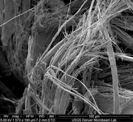
Scanning electron microscope (SEM) image of "wooly" erionite, a naturally occurring asbestos mineral. Image credit: Richard Sheppard, USGS
What is Naturally Occurring Asbestos (NOA)?
“Asbestos” is an industrial, not mineralogical, term that refers to six carcinogenic minerals regulated under federal law: chrysotile, crocidolite, amosite, anthophyllite, tremolite, and actinolite2,3. These six minerals were heavily used for commercial purposes before the discovery that occupational exposure carries serious risk of disease. The term “Naturally Occurring Asbestos” (NOA), on the other hand, refers to the six federally-regulated asbestos minerals as well as other fibrous minerals found in rocks and soils that can negatively impact human health when inhaled. NOA inhalation may occur when the minerals become airborne due to natural weathering or human activity4.
Case Study: Erionite in North Dakota
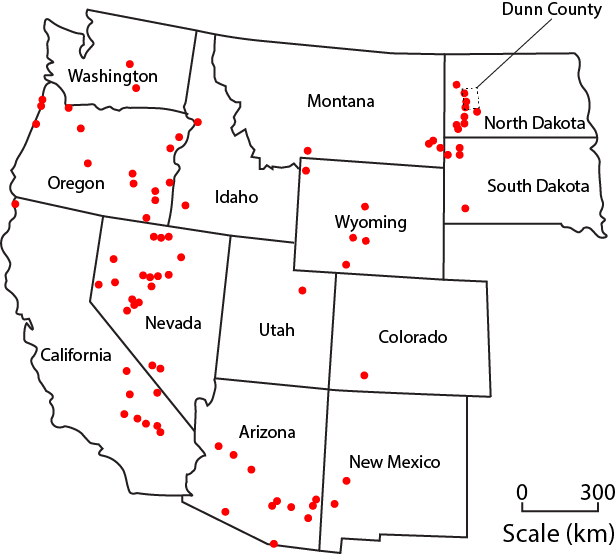
Erionite is a naturally occurring asbestos (NOA) mineral and Group 1 known respiratory carcinogen5,6 that has been found on every continent and in at least twelve US states7. Similar to regulated asbestos, the fibrous shape of microscopic erionite crystals allows them to become embedded in a person’s lungs when inhaled. Exposure to erionite or other NOA minerals can have detrimental health effects, such as respiratory disease, various cancers, cardiovascular disease, and depressed immune function2. In the Cappadocia region of Turkey, prolonged exposure to airborne erionite has been linked to unusually high numbers of fatalities from malignant mesothelioma, a rare lung cancer also associated with asbestos8,9.
In western North Dakota, erionite is found in volcanic rocks that for many decades were quarried for aggregate, which was used to construct over 300 miles of gravel roads in Dunn County, ND8. Driving on or otherwise disturbing these roads can create dust clouds containing airborne erionite. Playgrounds, baseball diamonds, parking lots, and other heavily trafficked public works were also paved with the gravel10.
Map of erionite occurrences in the Western U.S. Figure created by Abby Ackerman for AGI, modeled after Van Gosen et al.(2013), "Geologic occurrences of erionite in the United States: an emerging national public health concern for respiratory disease"
Response to Erionite in North Dakota
Once geologists realized the health risks associated with erionite-bearing aggregate from Dunn County, and that the county had been using it for decades, interdisciplinary work began to assess erionite exposure and protect the public. Because the areas with erionite-bearing rocks had already been mapped in detail by the North Dakota Geological Survey (NDGS), general avoidance maps were quickly created and sent to the Environmental Protection Agency (EPA) and other agencies. Beginning in 2006, geoscientists from the U.S. Geological Survey (USGS), the NDGS, and several universities took samples of the road gravel and dust clouds to determine how much erionite was present. Comparing the erionite samples from North Dakota with those from Turkey10, researchers found both samples have similar physical and chemical properties. Although most of the measured airborne concentrations of erionite in North Dakota were lower than those from the Turkish villages with the highest mortality rates from mesothelioma, concentrations were comparable to those in other areas that have elevated rates of erionite-related disease, leading researchers to conclude that there is still reason for concern8.
Health officials and the North Dakota Department of Transportation recommended halting the use of the erionite-bearing aggregate and covering roads with other gravel or tar to decrease the chances of erionite dust being inhaled, or removing the gravel altogether10. The highest priority was given to areas where children would be exposed due to the effects of prolonged exposure, and additional precautions were taken for workers who would regularly come into contact with erionite dust. While studies of the effects of erionite on public health in North Dakota are ongoing, lessons learned from Dunn County can inform protocols for protecting residents in other areas.
In 2012, USGS began increasing geologic mapping efforts to assist with updating the map of erionite occurrences nationwide11,12. Accurate geologic maps are integral to preventing unintentional exposure to this natural hazard. With a firm understanding of the distribution of erionite, planners, engineers, quarry- and mining companies, public health experts, and communities can make well-informed decisions about activities that might put public health at risk.
More Resources
National Cooperative Geologic Mapping Program, U.S. Geological Survey
Erionite, North Dakota Department of Health, Environmental Health
USGS Environmental Health Mission Area, U.S. Geological Survey
Asbestos found in Nevada and Arizona: Roadblock and potential health hazard?, EARTH Magazine
Dangerous dust: Erionite - an asbestos-like mineral causing a cancer epidemic in Turkey - is found in at least 13 states, EARTH Magazine
References
1 Health Risk of Radon, U.S. Environmental Protection Agency
2 Toxicological Profile for Asbestos, Agency for Toxic Substances & Disease Registry, Centers for Disease Control and Prevention
3 Workplace Safety and Health: Asbestos, National Institute for Occupational Safety and Health, Centers for Disease Control and Prevention
4 Naturally Occurring Asbestos: Potential for Human Exposure, Southern Nevada, USA, Soil Science Society of America Journal
5 IARC Monographs on the Evaluation of Carcinogenic Risks to Humans, Vol. 100C (2012), Erionite, World Health Organization International Agency for Research on Cancer
6 National Toxicology Program 14th Report on Carcinogens - Erionite, U.S. Department of Health and Human Services
7 Occurences of erionite in sedimentary rocks of the Western United States, U.S. Geological Survey
8 Erionite exposure in North Dakota and Turkish villages with mesothemlioma, Proceedings of the National Academy of Sciences
9 The Cappadocia mesothelioma epidemic: its influence in Turkey and abroad, Annals of Translational Medicine
10 Erionite, North Dakota Department of Health, Environmental Health
11 USGS support to advance erionite research, Environmental Factor
12 Geologic occurrences of erionite in the United States: an emerging national public health concern for respiratory diesease, Environmental Geochemistry and Health

This work is licensed under a Creative Commons Attribution-NonCommercial-NoDerivatives 4.0 International License.
You are free to share or distribute this material for non-commercial purposes as long as it retains this licensing information, and attribution is given to the American Geosciences Institute.


