The National Cooperative Geologic Mapping Program (NCGMP)
")
Geologic Mapping
In 1992, Congress established the National Cooperative Geologic Mapping Program (NCGMP) in the U.S. Geological Survey to address the nationwide need for detailed geologic mapping. The NCGMP coordinates Federal, State, and academic programs to leverage all their mapping capabilities and manages a publicly available database of geologic maps. National geologic mapping priorities are determined with the aid of the NCGMP advisory committee.
Geologic Maps
Geologic maps provide vital information for land-use planning, resource identification, and natural hazard avoidance, and are critical for growing the economy. Less than 50 percent of the conterminous U.S. has been mapped at the appropriate level of detail for today’s challenges. Advances in technology allow the Program to move beyond traditional map formats to provide comprehensive, multi-resolution, three-dimensional, digital information that can be readily customized for a wide range of users.
Activities and Responsibilities
Although geologic mapping is undertaken by Federal, State, Local, and academic geoscience institutions, no one group has the capability to meet our Nation’s current and future needs. The NCGMP is the bridge connecting stakeholder resources, expertise, and geographic distribution to create high-quality geologic maps. NCGMP’s coordinating role ensures cost-efficiency as well as timely delivery of products to the public. The main activities and responsibilities of the NCGMP are to:
- Create maps to solve critical societal and scientific issues determined to be vital to the welfare and security of the nation
- Establish mapping standards and guidelines to ensure quality, utility, and interoperability
- Maintain a database for geologic maps, reports, and metadata and provide timely public access
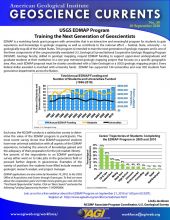
- Train the next generation of geologic mappers and researchers
 geologic map coverage in the United States as of 2010. Completed geologic maps will still require updates, such as reconciling edge discrepancies when compiling adjacent maps or converting older maps")
Map of detailed (scale of 1:100,000 or more detailed) geologic map coverage in the United States as of 2010. Completed geologic maps will still require updates, such as reconciling edge discrepancies when compiling adjacent maps or converting older maps.
The Program Components
The NCGMP has three components:
FEDMAP is the federal component of the NCGMP. FEDMAP funds multi-year geologic research and mapping projects lead by USGS scientists in high-priority areas that establish regional geologic frameworks and advance scientific research that can then be applied to a variety of societally relevant issues. FEDMAP research areas often cross state lines and commonly focus on federal lands.
STATEMAP, the state component of the NCGMP, is a cooperative funds-matching agreement between the USGS and state geological surveys. For each STATEMAP project, the NCGMP provides 50 percent of the funding and the state surveys provide the other 50 percent. Through STATEMAP, state surveys run year-long geologic mapping projects to address societally relevant issues in their states. STATEMAP priorities in each state are set with input from their State Mapping Advisory Committee; these committees include representative residents from across multiple sectors to ensure that the proposed geologic mapping projects will be meaningful to the state.
EDMAP, the academic component of the NCGMP, trains college and university students to be the next generation of geologic mappers. Like STATEMAP, EDMAP is a cooperative funds-matching agreement where universities match the funds provided by the NCMGP at a 1:1 ratio. Professors can apply for funding for graduate and upper-level undergraduate students, who then create their own geologic maps and reports that they can publish as primary author. EDMAP projects are often carried out in close cooperation with FEDMAP and STATEMAP.
The National Geologic Map Database (NGMDB) manages the final products of NCGMP component projects, compiling maps and reports into a single accessible database. The NGMDB also creates scientific and technical standards and guidelines to ensure that the geospatial products of NCGMP projects are uniform in their naming conventions, symbols, and other technical elements.

A geologist taking measurements of an outcrop to create a geologic map. Image credit: Hanif Jawid, AGI Life in the Field 2015.
For more information on NCGMP, please visit https://ncgmp.usgs.gov/.
More resources on geologic mapping:
- Geologic Mapping to Empower Communities: Examples from the Great Lakes, AGI Webinar
- Geologic Mapping and Public Health, AGI Factsheet
- Geologic Mapping and the Trans-Alaska Pipeline, AGI Factsheet
- Using Geologic Maps to Reduce Landslide Risk, AGI Factsheet
- 2019 Synopsis of Three-dimensional Geological Mapping and Modelling at Geological Survey Organizations, Alberta Energy Regulator / Alberta Geological Survey, AER/AGS Special Report 112

This work is licensed under a Creative Commons Attribution-NonCommercial-NoDerivatives 4.0 International License.
You are free to share or distribute this material for non-commercial purposes as long as it retains this licensing information, and attribution is given to the American Geosciences Institute.