Managing resources in an oil- and gas-rich but harsh and fragile environment
Introduction
The Arctic hosts large oil and natural gas resources both onshore and offshore.1 However, the harsh climate, extreme weather, remote locations, and limited infrastructure make exploration and production expensive and sometimes hazardous. In recent decades, decreased summer sea ice has resulted in increased shipping traffic and may encourage more offshore oil and gas exploration and production. Many concerns over the environmental impact of these activities are based on the Arctic’s fragile, undisturbed ecosystems and the difficulty of monitoring and responding to spills due to remote locations, long, cold winters, and the lack of an Arctic deepwater port to handle emergency response vessels and equipment.2
In 2018, the intersection between oil, gas, and the Arctic environment is a topic of much current discussion due to recent federal decisions to expand federal oil and gas leasing in the coastal area of the Arctic National Wildlife Reserve (the “1002 area”), in a larger area of the National Petroleum Reserve-Alaska (NPRA), and offshore.3 Concerns over increased environmental risks in a region already experiencing rapid environmental and climatic changes are often weighed against the economic benefits of increased exploration and production. Attempting to balance these priorities, the National Environmental Policy Act (NEPA) requires that, before any exploratory studies are authorized, federal agencies must consider impacts on sociocultural, economic, and other natural resources in consultation with other government agencies and the public.
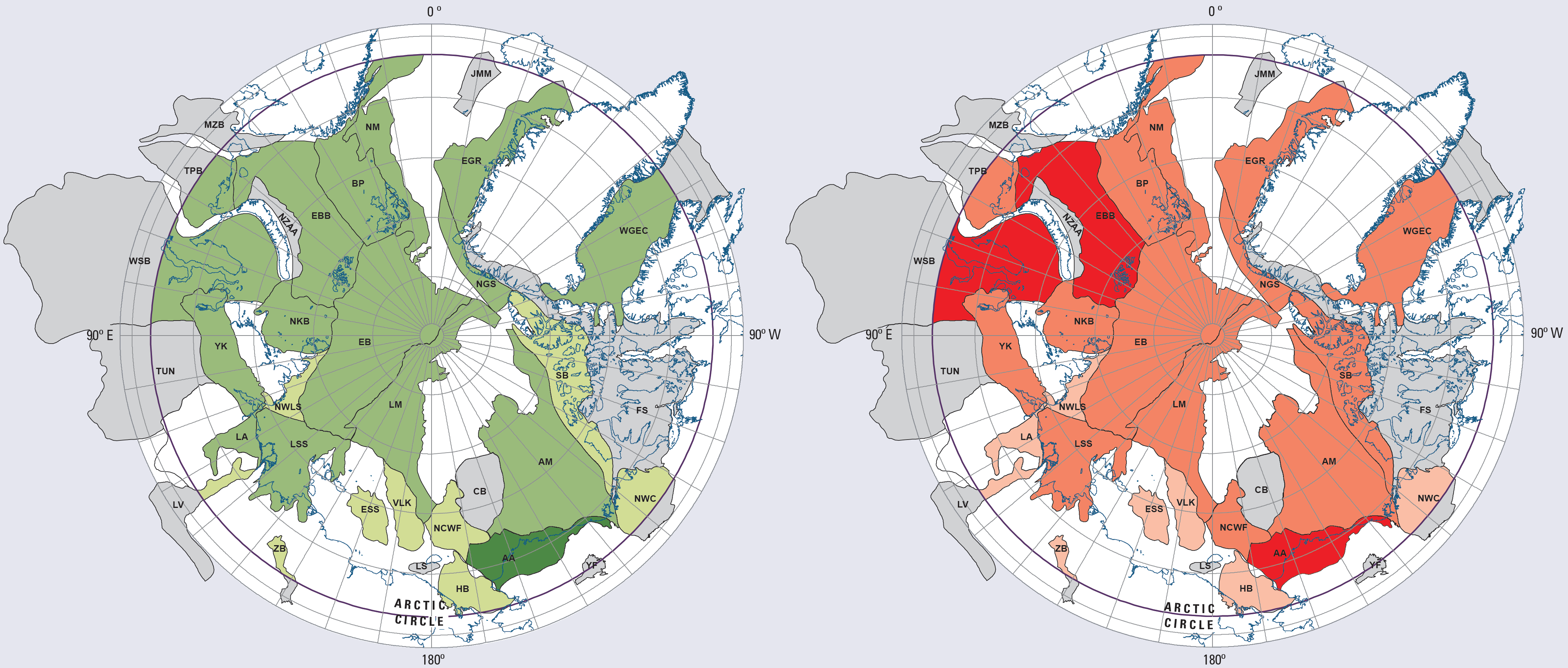
Estimated undiscovered oil (green, left) and gas (red, right) in the Arctic, according to the U.S. Geological Survey (2008). Greenland is in the top-right of each map, Alaska in the bottom-right (“AA” region covers Alaska’s North Slope). Colors: undiscovered oil (greens) – dark = >10 billion barrels, medium = 1–10, light = <1; undiscovered gas (reds) – dark = >100 trillion cubic feet; medium = 6–100; light = <6. Image Credit: U.S. Geological Survey1
Land Ownership and U.S. Arctic Development
Although the federal government controls 60% of Alaskan land and all the ocean between the limits of state and international waters (i.e., from 3 to 200 nautical miles offshore), much of the oil and gas development to date has been on state and Native land around Prudhoe Bay in Alaska’s North Slope.
National Petroleum Reserve-Alaska (NPRA):4 The Reserve is a 23.6-million-acre tract of federal land set aside in 1923 to ensure future oil supplies for the U.S. Navy. Oil and gas resources in NPRA are significant but difficult to pinpoint because estimates change as exploration proceeds and additional data become available.6 Leasing for oil and gas production in NPRA began in the 1980s, but development has been slow due to complex regulatory processes and the difficulty of operating in environmentally sensitive areas far from established infrastructure.
Arctic National Wildlife Refuge (ANWR): The Refuge was initially protected in 1960; in 1980, it was expanded and parts were designated as wilderness to preserve their unique wildlife, wilderness, and recreational value.7 At the same time, Congress set aside an area on the North Coast (the “1002 area”) to allow for future development of potentially large oil and gas resources.8 The tax reform bill of 2017 (Public Law 115-97) opened the 1002 area to energy development.9 This is the first time since 1980 that the 1002 area has been open to leasing or any activity (such as geophysical surveys) that could lead to producing oil or natural gas.3
State and Native Lands: 28% of Alaska is state-owned and 12% is Native land. As of early 2018, all onshore Alaskan North Slope oil production is on either state or Native lands, including from Native lands on the boundaries of NPRA. Production from federal lands in NPRA is expected to start in the near future.
Offshore: The state of Alaska regulates resources up to 3 nautical miles from the coast. From 3 to 200 nautical miles offshore, resources are regulated by the federal government.10 One notable offshore oilfield is the Northstar Oil Pool, which is located in both state and federal waters near Prudhoe Bay. Production in federal waters started here in 2001 from a man-made gravel island 6 miles offshore.11 Future production is expected in both state and federal waters near existing onshore oil fields in the North Slope area. In 2017, the U.S. Department of the Interior started a multi-year process to develop a new five-year leasing plan that would allow large areas of offshore Alaska to be leased.12
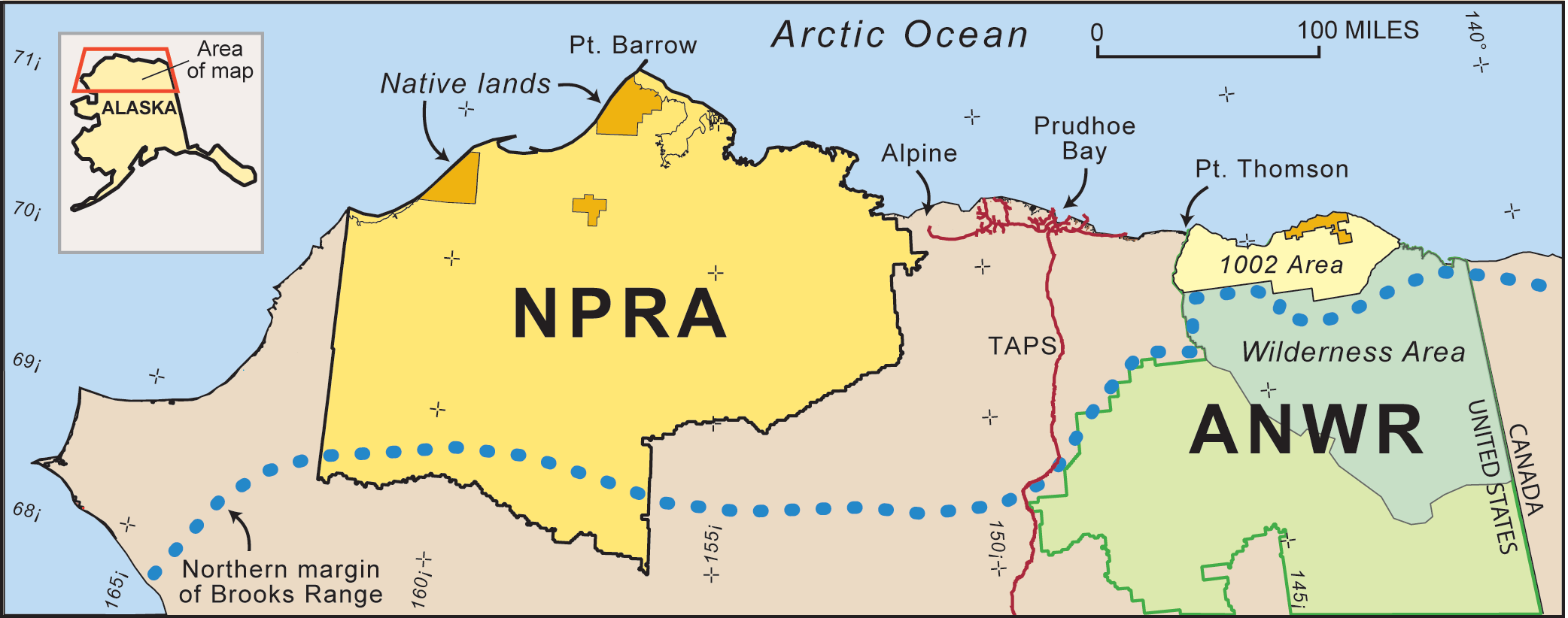
Oil and gas in the North Slope region of Alaska (north of the dotted blue line). Red lines are pipelines. Federal lands include the National Petroleum Reserve–Alaska (NPRA) and the Arctic National Wildlife Refuge (ANWR), which includes wilderness (darker green) and 1002 (light yellow) areas.4 See text for more information about the features in this map. Image credit: U.S. Geological Survey5
Regulation of U.S. Arctic Drilling
Oil and gas development on federal land is regulated by the U.S. Bureau of Land Management. On state and Native lands, and in state waters, drilling and production of oil and gas and the underground disposal of oilfield waste are overseen by the Alaska Oil and Gas Conservation Commission.13
In federal waters, the U.S. Bureau of Ocean Energy Management (BOEM) manages leasing, including resource assessments to estimate potential lease value, and review and approval of drilling plans, including any necessary environmental assessments. The Bureau of Safety and Environmental Enforcement (BSEE) regulates all offshore drilling and production activities. The Arctic Drilling Rule released by BSEE in 201614 requires rigorous safety controls beyond those required in other offshore areas. These include having equipment on hand to cap an out-of-control well and capture any leaking oil, and having access to a separate rig that can drill a relief well and plug a compromised well permanently before seasonal ice encroaches on the drill site or within 45 days, whichever is sooner. Although improvements have been made, the safety and environmental impacts of offshore oil and gas development in the Arctic remain highly controversial.15,16
Reducing Surface Impacts on Alaska’s North Slope
Oil production on the North Slope of Alaska began in 1977. The developed area is focused on a narrow coastal strip running about 100 miles east to west in the vicinity of Prudhoe Bay (see map). In the 1970s and 80s, access roads, well sites, oil and gas processing facilities, and support facilities were constructed using gravel. By the early 2000s, roughly 9,200 acres were under gravel.17 More recent exploration reduces the surface impact by using ice roads and ice drilling sites that are constructed each winter, and small gravel production sites with multiple wells per site. For example, the Alpine field, which was discovered in 1994 to the west of the older oilfields,18 uses about 100 acres of gravel drill pads, facilities, and roads to tap a 25,000-acre oil reservoir – as of early 2018, the field had produced 465 million barrels of oil.19 In 2018, Greater Mooses Tooth-1, a field located in NPRA, west of Alpine, will begin producing oil from a single 12-acre gravel drill pad designed to support 33 wells.20 Eight miles of gravel road and parallel above-ground pipeline, including two bridges, will connect the pad to existing Alpine field facilities, for a total gravel footprint of 73 acres.
Oil Pipelines
North Slope oil is collected by a network of local pipelines and then sent 800 miles through the Trans-Alaska Pipeline System (TAPS) to the south coast of Alaska. Except for small quantities refined in Alaska, most of the oil is loaded onto tankers and shipped to refineries on the West coast or occasionally in Hawaii. In areas where the soil is either permanently frozen (permafrost) or never freezes, the Trans-Alaska Pipeline is buried; in areas where the ground freezes and thaws with the seasons, the pipeline is generally elevated above ground.21 Where highways, animal crossings, or unstable hillslopes required pipeline burial in unstable permafrost, insulation or refrigeration is used to keep the ground cold.22 Safety features include systems that monitor variations in pipeline flow and pressure to alert response teams to the location of probable leaks;22 tracks that allow the pipeline to move without breaking during earthquakes (see photo);23 and heat transfer pipes that move heat from the buried pipe to the air, helping keep permafrost cold and stable.22
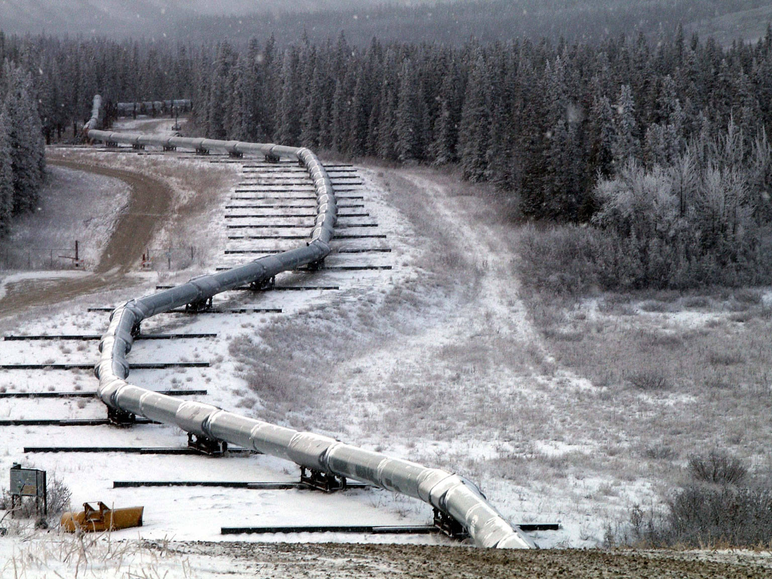
The Trans-Alaska oil pipeline is mounted on sliders where it crosses the Denali fault. During a large (magnitude 7.9) earthquake in 2002, this system allowed the pipeline to move without breaking. Image credit: Tim Dawson, U.S. Geological Survey24
Oil Spills
A 2013 BOEM analysis of oil spills in the North Slope area between 1971 and 2011 identified 1,577 spills larger than 42 gallons (one barrel), 10 spills larger than 21,000 gallons, and two spills larger than 42,000 gallons.25 In 2017, the Alaska Division of Spill Prevention and Response recorded 18 crude oil spills on the North Slope, releasing a total of 1,010 gallons of oil.26 Spills of other operational fluids are more common: in 2017 there were 147 recorded spills of diesel, engine lube oil, gasoline, hydraulic oil, and produced water on the North Slope, totaling 43,000 gallons.
The largest North Slope oil spill occurred in 2006, when a pipeline leaked 267,000 gallons of crude oil onto the tundra in the Prudhoe Bay field. The leak was caused by the operator (BP)’s failure to prevent internal corrosion in a 29-year-old pipeline that had not been properly maintained and inspected. BP was fined $25 million and required to implement a system-wide pipeline integrity management program.27 Cleanup operations included removing oil from snow and vegetation without disturbing the tundra and underlying soils, preventing the spread of leaked oil into nearby lakes, and restoring the site of the spill.28
The U.S. Bureau of Safety and Environmental Enforcement supports research into offshore spill response in the presence of sea ice, cold temperatures, and the hazardous conditions of the Arctic. Studies on improved spill cleanup include mechanical cleanup, in-situ burning, and chemical treating agents. Research also investigates improved oil detection methods for locating spills.29
In 1989, the Exxon Valdez oil tanker was carrying North Slope oil when it ran aground and ruptured, spilling 11 million gallons of crude oil into Prince William Sound in southern Alaska. This spill was the largest oil spill in the United States until the 2010 Deepwater Horizon disaster, which was almost 20 times larger. Shipping regulations developed in response to the spill, and supplemented in 2009, primarily focus on Alaskan oil exports. Regulations now require double-hulled tankers, tugboat escorts with spill response capability, U.S. Coast Guard electronic tracking throughout Prince William Sound and 60 miles into the Gulf of Alaska, and local availability of response and recovery equipment and trained personnel.30 The National Oceanic and Atmospheric Administration continues to monitor the ongoing wildlife recovery from the Exxon Valdez spill.31
More Resources
National Academies Ocean Studies Board (2014). Responding to Spills in the U.S. Arctic Marine Environment.
Arctic Council. Intergovernmental forum for sustainable development and environmental protection in the Arctic.
National Petroleum Council (2015). Arctic Potential: Realizing the Promise of U.S. Arctic Oil and Gas Resources.
Pew Charitable Trusts – Arctic Standards.
References
1 U.S. Geological Survey (2008). Circum-Arctic Resource Appraisal: Estimated of Undiscovered Oil and Gas North of the Arctic Circle. Fact Sheet 2008-3049.
2 Alaska Department of Transportation & Public Facilities – Arctic Port Study.
3 Comay, L.B. et al. (2018). Arctic National Wildlife Refuge (ANWR): An Overview. Congressional Research Service, 7-5700, January 9, 2018.
4 U.S. Bureau of Land Management – National Petroleum Reserve in Alaska.
5 Attanasi, E.D. (2003). Economics of Undiscovered Oil in the Federal Lands of the National Petroleum Reserve, Alaska. U.S. Geological Survey Open-File Report 03-044.
6 U.S. Geological Survey (2017). Assessment of Undiscovered Oil and Gas Resources in the Cretaceous Nanushuk and Torok Formations, Alaska North Slope, and Summary of Resource Potential of the National Petroleum Reserve in Alaska, 2017. Fact Sheet 2017-3088.
7 U.S. Fish and Wildlife Service – Arctic: National Wildlife Refuge-Alaska.
8 U.S. Geological Survey – Arctic National Wildlife Refuge, 1002 Area, Petroleum Assessment, 1998 (revised), Including Economic Analysis. Fact Sheet 0028-01: Online Report.
9H.R. 1 – An Act to provide for reconciliation pursuant to titles II and V of the concurrent resolution on the budget for fiscal year 2018. 115th Congress (2017-2018).
10 U.S. Bureau of Ocean Energy Management – Outer Continental Shelf.
11 Alaska Oil and Gas Conservation Commission – Northstar Oil Pool Statistics.
12 Bureau of Ocean Energy Management – 2019-2024 National Outer Continental Shelf Oil and Gas Leasing Program.
13Alaska Oil and Gas Conservation Commission.
14 U.S. Bureau of Safety and Environmental Enforcement – Fact Sheet: Arctic Drilling Rule.
15 The Pew Charitable Trusts (2013). Arctic Standards: Recommendations on Oil Spill Prevention, Response, and Safety in the U.S. Arctic Ocean.
16 “The Only Safe Arctic Drilling is No Arctic Drilling.” Natural Resources Defense Council Press Release, July 7, 2016.
17 National Research Council (2003). Cumulative Environmental Effects of Oil and Gas Activities on Alaska’s North Slope. Washington, DC: The National Academies Press.
18 Alaska Oil and Gas Conservation Commission – Colville River Unit, Alpine Oil Pool.
19 Alaska Oil and Gas Conservation Commission – Production.
20 U.S. Bureau of Land Management (2015). Supplemental Environmental Impact Statement for the Alpine Satellite Development Plan for the Proposed Greater Mooses Tooth One Development Project: Record of Decision, February 2015.
21 Alyeska Pipeline Service Company – Safety & Environment: Permafrost.
22 Alyeska Pipeline Service Company – Trans Alaska Pipeline System Facts.
23 Alyeska Pipeline Service Company – Earthquake Protection.
24 U.S. Geological Survey – Denali Fault: Alaska Pipeline.
25 Nuka Research and Planning Group (2013). Oil Spill Occurrence Rates for Alaska North Slope Crude & Refined Oil Spills. Report to the Bureau of Ocean Energy Management, October 2013. OCS Study BOEM 2013-205.
26 Alaska Department of Environmental Conservation – PRP Spills Database Search.
27 “BP Exploration Alaska to Pay $25 Million Penalty for Alaskan North Slope Oil Spill.” U.S. Department of Justice, May 3, 2011.
28 Alaska Department of Environmental Conservation – GC-2 Transit Line Spill: Tundra Treatment Plan Rev.1, March 18, 2006.
29 U.S. Bureau of Safety and Environmental Enforcement – Arctic Oil Spill Response Research.
30 Alaska Department of Environmental Conservation – 30 Years after the Exxon Valdez.
31 U.S. National Oceanic and Atmospheric Administration – 25 Years Later: Timeline of Recovery from Exxon Valdez Oil Spill.
32 U.S. Bureau of Safety and Environmental Enforcement – International Forums: The Arctic Offshore Regulators Forum (AORF).
33 U.S. Energy Information Administration – Alaska North Slope Crude Oil Production.
Petroleum and the Environment
Download a full PDF of Petroleum and the Environment (free) or purchase a printed version ($19.99).
Other parts in this series:
1. Petroleum and the Environment: an Introduction
2. Water in the Oil and Gas Industry
3. Induced Seismicity from Oil and Gas Operations
4. Water Sources for Hydraulic Fracturing
5. Using Produced Water
6. Groundwater Protection in Oil and Gas Production
7. Abandoned Wells
8. What Determines the Location of a Well?
9. Land Use in the Oil and Gas Industry
10. The Pinedale Gas Field, Wyoming
11. Heavy Oil
12. Oil and Gas in the U.S. Arctic
13. Offshore Oil and Gas
14. Spills in Oil and Natural Gas Fields
15. Transportation of Oil, Gas, and Refined Products
16. Oil Refining and Gas Processing
17. Non-Fuel Products of Oil and Gas
18. Air Quality Impacts of Oil and Gas
19. Methane Emissions in the Oil and Gas Industry
20. Mitigating and Regulating Methane Emissions
21. Regulation of Oil and Gas Operations
22. Health and Safety in Oil and Gas Extraction
23. Subsurface Data in the Oil and Gas Industry
24. Geoscientists in Petroleum and the Environment
Glossary of Terms
References
Arctic Resources by the Numbers1,33
- The Arctic accounts for 6% of the Earth’s surface but 10% of the conventional oil and gas discovered and produced to date.
- Undiscovered but recoverable “conventional” resources in the Arctic are estimated at 90 billion barrels of oil (16% of global total), 1,669 trillion cubic feet of gas (30%), and 44 billion barrels of natural gas liquids (38%). 84% of this is offshore.
- In 2016, Alaska’s North Slope region produced about 5.5% of U.S. oil: 173 million barrels onshore and 6.2 million barrels offshore.
- North Slope peak oil production in 1988 was 720 million barrels, over 23% of all U.S. production.
- Alaskan oil production dropped over 75% from 1988 to 2015 as fields discovered in the 1960s were gradually depleted. New discoveries may change this trend.
Who are the Arctic Oil & Gas Producers?
As of 2018, three nations produce oil and gas north of the Arctic Circle: the U.S. (Alaska), Russia, and Norway. Canada, Greenland, Iceland, Sweden, and Finland currently have no Arctic production. Production may expand to other arctic nations in the future. Canada, Finland, Iceland, the Kingdom of Denmark (Greenland), Norway, Russian, and the United States exchange information, best practices, and regulatory experiences through the Arctic Offshore Regulators Forum.32


