Geoscience in Your State: Colorado

PDF versionPDF version
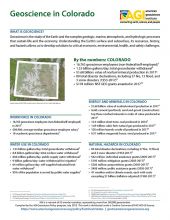
Cover of Geoscience Policy State Factsheet. Image credit: AGI

By the numbers: Colorado

  • 16,763 geoscience employees (excludes self-employed)1
  • 1.53 billion gallons/day: total groundwater withdrawal3
  • $1.68 billion: value of nonfuel mineral production in 20174
  • 80 total disaster declarations, including 57 fire, 13 flood, and 3 snow disasters (1953-2017)⁶
  • $178 million: NSF GEO grants awarded in 201714
...

Agencies Working on Geoscience Issues in colorado

Colorado Department of Public Health and Environment

The mission of the Colorado Department of Public Health and Environment is to protect and improve the health of Colorado’s people and the quality of its environment

Colorado Division of Homeland Security and Emergency Management

The mission of the Colorado Division of Homeland Security and Emergency Management is to provide leadership and support to Colorado communities to prevent, protect, mitigate, respond and recover from all-hazard events including acts of terrorism.

Colorado Division of Reclamation Mining & Safety

The Colorado Division of Reclamation, Mining and Safety is responsible for mineral and energy development, policy, regulation and planning. The division is comprised of the Office of Mined Land Reclamation and the Office of Active and Inactive Mines.

Colorado Division of Water Resources

The mission of the Colorado DWR is to provide competent and dependable distribution of water in accordance with statutes, decrees and interstate compacts; to ensure public safety through safe dams and properly permitted and constructed water wells; to maintain and provide accurate and timely information concerning water; to promote stewardship of all human, fiscal and natural resources; to serve the public through the generation of creative solutions to problems; to help the public understand complex water issues; to promote stability in the use of the state's limited water resources; and to apply modern technology to its greatest advantage.

Colorado Geological Survey
The mission of the Colorado Geological Survey is building vibrant economies and sustainable communities, free from geologic hazards, for people to live, work and play through good science, collaboration, and sound management of mineral, energy and water resources.
Colorado Oil and Gas Conservation Commission

The mission of the Colorado Oil and Gas Conservation Commission (COGCC) is to foster the responsible development of Colorado's oil and gas natural resources.

Colorado Water Conservation Board

The mission of the Colorado Water Conservation Board is to conserve, develop, protect and manage Colorado’s water for present and future generations.

Case Studies & Factsheets

Cover of Using Produced Water

Opportunities and Concerns in Using Produced Water Produced water is natural groundwater that is extracted along with oil and gas. It is commonly salty and mixed with oil residues,1 so it must be either disposed of or treated and reused. About 2.5 billion gallons of produced water are extracted...

Cover of Geoscience Policy State Factsheet. Image credit: AGI

By the numbers: Colorado 16,763 geoscience employees (excludes self-employed)1 1.53 billion gallons/day: total groundwater withdrawal3 $1.68 billion: value of nonfuel mineral production in 20174 80 total disaster declarations, including 57 fire, 13 flood, and 3 snow disasters (1953-2017)⁶ $178...

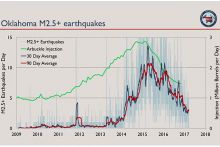
Cover of Induced Seismicity from Oil and Gas Operations

Manmade Earthquakes Any activity that significantly changes the pressure on or fluid content of rocks has the potential to trigger earthquakes. This includes geothermal energy production, water storage in large reservoirs, groundwater extraction, underground injection of water for enhanced oil...

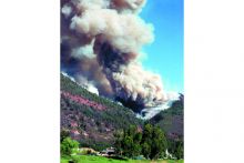
Fig. 1. Homeowners and emergency managers are still coping with debris flows and the aftermath of the 2002 Missionary Ridge wildfire near Durango, CO. Credit: P. Winkworth

Geologic maps are useful in identifying areas that may be affected by post-wildfire debris flows. Land-use planners use these maps to identify potential hazards in areas that are proposed for development and to develop mitigation strategies. The maps can also focus post-wildfire emergency planning...

CI_Factsheet_2017_2_groundwater_170309_thumb.JPG

Fresh water from underground Groundwater is any water found underground in the cracks and pores in soil, sand, or rock. Groundwater provides 25% of the fresh water used in the United States.1 It is particularly important for irrigation and domestic uses in arid or remote areas, where surface water...

Cover of Water Sources for Hydraulic Fracturing

Hydraulic Fracturing and Water Demand Hydraulically fracturing a modern well can require millions of gallons of water for the initial fracturing process. This is a potential problem in arid regions with competing demands for fresh water (i.e. high water stress), such as Colorado and West Texas (see...

Cover of Groundwater Protection in Oil and Gas Production

Introduction The United States relies on groundwater for roughly 25% of its fresh water.1 This groundwater is found in porous, permeable rocks (aquifers) that often lie close to the Earth’s surface – the deepest freshwater aquifers are found more than 6,000 feet underground,2 but most are much...

Cover of Spills in Oil and Natural Gas Fields

Introduction Oilfield spills can harm wildlife and pose a risk to human health if they reach fresh water sources or contaminate soil or air. The enormous size of the oil and gas industry and the huge volumes of oil and produced water that are handled, stored, and transported result in thousands of...

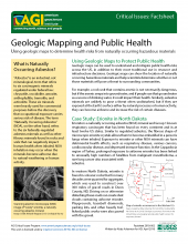
Cover of AGI Factsheet 2018-002-Geologic Mapping and Public Health

Using Geologic Maps to Protect Public Health Geologic maps can be used to understand and mitigate public health risks across the US, in addition to their more traditional use in resource and infrastructure decisions. Geologic maps can show the location of naturally occurring hazardous materials and...
CI_Factsheet_2017_5_drywellprograms_170906_thumb.JPG

Introduction Dry wells improve stormwater drainage and aquifer recharge by providing a fast, direct route for rainwater to drain deep into underlying sediment and rock. Dry wells are most common in the western U.S. where clay or caliche layers slow down the natural drainage of water into underlying...

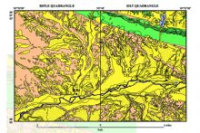
Fig. 1. Simplified geologic map of the Rifle and Silt quadrangles in Garfield County, CO. Yellow indicates unconsolidated sand and gravel deposits. Yellow with black dots indicates deposits of wind-blown silt (loess). Credit: USGS
In Garfield County, an area of multiple land uses, geologic maps show the location and quality of the sand and gravel resources. Planners, citizens, and resource developers use this information to locate and evaluate potential deposits and make informed land-use choices. Defining the Problem As...

Cover of Abandoned Wells

Introduction In 2017, there were one million active oil and gas wells in the United States.1 When a well reaches the end of its productive life, or if it fails to find economic quantities of oil or gas, the well operator is required by regulators to remove all equipment and plug the well to prevent...

Cover of AGI Factsheet 2018-004 - Present Day Climate Change

Climate Science 101 Climate is the average of weather conditions over several decades.1,2 Geoscientists monitor modern climate conditions (1880 A.D. to present) in part by taking direct measurements of weather data (i.e., air temperature, rainfall and snowfall, wind speed, cloudiness, and so on)...

1 of 13