Geoscience In Your State: California

PDF versionPDF version
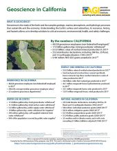
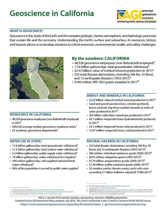
Cover of Geoscience Policy State Factsheet. Image credit: AGI

By the numbers: California

  • 48,528 geoscience employees (excludes self-employed)1
  • 17.4 billion gallons/day: total groundwater withdrawal3
  • $3.52 billion: value of nonfuel mineral production in 20174
  • 252 total disaster declarations, including 184 fire, 35 flood, and 12 earthquake disasters (1953-2017)6
  • $190 million: NSF GEO grants awarded in 2017...

Agencies Working on Geoscience Issues in california

California Department of Water Resources

In 1956, the Legislature passed a bill creating DWR to plan, design, construct, and oversee the building of the nation's largest state-built water development and conveyance system. Today, DWR protects, conserves, develops, and manages much of California's water supply including the State Water Project which provides water for 25 million residents, farms, and businesses.

Working with other agencies and the public, DWR develops strategic goals, and near-term and long-term actions to conserve, manage, develop, and sustain California's watersheds, water resources, and management systems. DWR also works to prevent and respond to floods, droughts, and catastrophic events that would threaten public safety, water resources and management systems, the environment, and property.

Balancing the State's water needs with environmental protection remains a long-term challenge.

California Division of Mine Reclamation

The Division of Mine Reclamation (DMR) was created to provide a measure of oversight for local governments as they administer the Surface Mining and Reclamation Act (SMARA) within their respective jurisdictions. To accomplish this goal, the Division of Mine Reclamation may provide comments to lead agencies on a mining operation’s reclamation plan and financial assurance and may initiate compliance actions that encourage SMARA compliance. While the primary focus is on existing mining operations and the return of those mined lands to a usable and safe condition, issues relating to abandoned legacy mines are addressed through the Abandoned Mine Lands program.

California Environmental Protection Agency

The California Environmental Protection Agency's mission is to restore, protect and enhance the environment, to ensure public health, environmental quality and economic vitality. This mission is fulfilled by developing, implementing and enforcing environmental laws that regulate air, water and soil quality, pesticide use and waste recycling and reduction.

California Geologic Energy Management Division

The California Geologic Energy Management Division (CalGEM), formerly the Division of Oil, Gas, and Geothermal Resources (DOGGR), prioritizes protecting public health, safety, and the environment in its oversight of the oil, natural gas, and geothermal industries, while working to help California achieve its climate change and clean energy goals. To do that, CalGEM uses science and sound engineering practices to regulate the drilling, operation, and permanent closure of energy resource wells.​

California Geological Survey

CGS's mission is to provide scientific products and services about the state's geology, seismology and mineral resources that affect the health, safety, and business interests of the people of California.

California Governor's Office of Emergency Services

The mission of the California Governor's Office of Emergency Services is to protect lives and property, build capabilities, and support communities for a resilient California

California Office of Environmental Health Hazard Assessment

OEHHA’s mission is to protect and enhance public health and the environment by scientific evaluation of risks posed by hazardous substances.

California State Mining and Geology Board

The mission of the State Mining and Geology Board is to provide profession​al expertise and guidance, and to represent ​the State's interest in the development, utilization, and conservation of mineral resources, the reclamation of mined lands, and the development and dissemination of geologic and seismic hazard information to protect the health and welfare of the people of California.

Case Studies & Factsheets

CI_CaseStudy_2017_2_MAR_170925_thumb.JPG

The Need for Groundwater Management: Sustaining water supplies and preventing hazards In California, surface water from rainfall, snowmelt, and distant rivers rarely meets the state’s urban and agricultural water needs. Groundwater is an essential water source, providing 35% of the fresh water used...
CI_CaseStudy_2017_1_VolcanicLandslides_thumb.JPG

More than just volcanic eruptions Volcanic eruptions are a serious hazard. But at many stratovolcanoes in Washington, Oregon, Northern California, and Alaska, landslides and debris flows can be just as dangerous. Some of these - especially volcanic mudflows (lahars) - are directly triggered by...

Cover of Using Produced Water

Opportunities and Concerns in Using Produced Water Produced water is natural groundwater that is extracted along with oil and gas. It is commonly salty and mixed with oil residues,1 so it must be either disposed of or treated and reused. About 2.5 billion gallons of produced water are extracted...

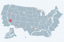
Screenshot of the USEITI case studies showing the Kern County case study highlighted

The U.S. Department of the Interior's Office of Natural Resources Revenue, Information and Data Management has produced a series of case studies on extractive industries across the United States, focusing on coal, copper, gold, iron, natural gas, and oil.

Cover of Heavy Oil

Introduction Naturally occurring crude oil comes in many forms. The most familiar to many people is light crude oil, which is less dense than water and flows easily at room temperature. Heavy oil and bitumen are forms of crude oil that are more viscous (thicker) and dense. The largest crude oil...

Cover of Subsurface Data in the Oil and Gas Industry

Introduction Drilling for oil and gas is expensive. A single well generally costs $5-8 million onshore and $100-200 million or more in deep water.1 To maximize the chances of drilling a productive well, oil and gas companies collect and study large amounts of information about the Earth’s...

Cover of Abandoned Wells

Introduction In 2017, there were one million active oil and gas wells in the United States.1 When a well reaches the end of its productive life, or if it fails to find economic quantities of oil or gas, the well operator is required by regulators to remove all equipment and plug the well to prevent...

CI_Factsheet_2017_7_ValleyFever_171205_thumb.JPG

What grows in arid, sandy soils? How do these soils become dust? Many small organisms, such as bacteria and fungi, grow among the sand and silt particles in dry valley and desert soils. At the soil’s surface, these organisms often form biological webs (“microbiotic crusts”) that keep small sand and...

Cover of AGI Factsheet 2018-002-Geologic Mapping and Public Health

Using Geologic Maps to Protect Public Health Geologic maps can be used to understand and mitigate public health risks across the US, in addition to their more traditional use in resource and infrastructure decisions. Geologic maps can show the location of naturally occurring hazardous materials and...

CI_Factsheet_2017_2_groundwater_170309_thumb.JPG

Fresh water from underground Groundwater is any water found underground in the cracks and pores in soil, sand, or rock. Groundwater provides 25% of the fresh water used in the United States.1 It is particularly important for irrigation and domestic uses in arid or remote areas, where surface water...

Cover of Geoscience Policy State Factsheet. Image credit: AGI

By the numbers: California 48,528 geoscience employees (excludes self-employed)1 17.4 billion gallons/day: total groundwater withdrawal3 $3.52 billion: value of nonfuel mineral production in 20174 252 total disaster declarations, including 184 fire, 35 flood, and 12 earthquake disasters (1953-...

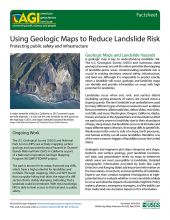
Cover of AGI Factsheet 2018-003--Using Geologic Maps to Reduce Landslide Risk

Geologic Maps and Landslide Hazards A geologic map is key to understanding landslide risk. The U.S. Geological Survey (USGS) and numerous state geological surveys around the nation prioritize the mapping of landslide-prone areas. Understanding landslide risk is crucial in making decisions around...

Cover of AGI Factsheet 2018-004 - Present Day Climate Change

Climate Science 101 Climate is the average of weather conditions over several decades.1,2 Geoscientists monitor modern climate conditions (1880 A.D. to present) in part by taking direct measurements of weather data (i.e., air temperature, rainfall and snowfall, wind speed, cloudiness, and so on)...

CI_Factsheet_2017_5_drywellprograms_170906_thumb.JPG

Introduction Dry wells improve stormwater drainage and aquifer recharge by providing a fast, direct route for rainwater to drain deep into underlying sediment and rock. Dry wells are most common in the western U.S. where clay or caliche layers slow down the natural drainage of water into underlying...

Cover of Air Quality Impacts of Oil and Gas

Introduction All widely used combustible fuels emit harmful (toxic or ozone-forming) gases and particles when burned to provide energy. These air pollutants can have a wide array of public health impacts, such as increasing the rate of certain cardiovascular (heart) and pulmonary (lung) diseases,...

CI_Factsheet_2017_4_drywellbasics_170906_thumb.JPG

What is a Dry Well? A dry well is a well that is used to transmit surface water underground and is deeper than its width at the surface (see image, below). Most dry wells are 30 to 70 feet deep and 3 feet wide at the surface. They are lined with perforated casings and can be filled with gravel or...

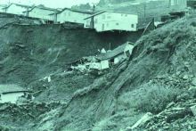
Fig.1. Home in Oakland, CA, destroyed by landslides in 1958. Source: J. Coe, USGS

In California, detailed modern geologic maps are fundamental for evaluating how susceptible an area is to earthquake-induced landslides. Defining the Problem The geologic history of the Oakland, California, area has produced steep hillsides and unstable rock and soil that generate damaging...

Cover of Mitigating and Regulating Methane Emissions

Introduction Methane is the main component of almost all natural gas, and gas delivered to end-users is purified to 95-98% methane.1 There are three main sources of methane emissions from the oil and gas industry: When a well is being drilled, cleaned out, or hydraulically fractured. As the fluids...

1 of 18